|
previous topic :: next topic |
| Author |
Message |
bobgatpdx

Since 04 Oct 2008
218 Posts
Stoked
|
 Mon Mar 20, 17 9:04 am High water Rooster launch? Mon Mar 20, 17 9:04 am High water Rooster launch? |
 |
|
Looks good on RoosterCam today, but the pole is almost submerged.
Anyone have tips for early season launching/landing at Rooster?
- Bob
_________________
RoosterCam Guy
pdxgreen.com/RoosterCam.php |
|
|
chrissmack

Since 08 Jun 2005
528 Posts
portland
Addicted
|
 Mon Mar 20, 17 11:41 am Mon Mar 20, 17 11:41 am |
 |
|
WOW!!
anYone got a pic of what the suavie island burm looks like right now?
|
|
|
bigjohn
Since 13 Mar 2012
663 Posts
Addicted
|
 Mon Mar 20, 17 12:36 pm Re: High water Rooster launch? Mon Mar 20, 17 12:36 pm Re: High water Rooster launch? |
 |
|
| bobgatpdx wrote: | Looks good on RoosterCam today, but the pole is almost submerged.
Anyone have tips for early season launching/landing at Rooster?
- Bob |
Those mangroves under water would be like a spider web with the force of 400,000 CFS of water blasting you through them if your kite goes down.
Be safe out there...
_________________
Kiting starts at 40MPH |
|
|
bobdigital
Since 29 Aug 2016
67 Posts
|
 Tue Mar 21, 17 6:18 am Tue Mar 21, 17 6:18 am |
 |
|
| I drove out to sauvies this weekend. The water is all the way to the burm. Hopefully the river level drops soon.
|
|
|
Justsmile

Since 20 Jul 2009
1527 Posts
Not Portland
XTreme Poster
|
 Tue Mar 21, 17 6:48 am Tue Mar 21, 17 6:48 am |
 |
|
Rivers are full. Most will hold for at least 2 weeks. Most tributaries are 2-3 ' from flood stage. Warm temps and lots of snow. Won't see beach til may!!
_________________
Take a breath; inhale |
|
|
Mtjustice100
Since 14 Jun 2014
49 Posts
|
 Tue Mar 21, 17 12:05 pm Tue Mar 21, 17 12:05 pm |
 |
|
| I have paddled across the Channel with kite and pump on my back, out to the sandy island... but the water is way more raging right now and just as cold. It was a bit of a gnarly mission but it did work... wouldn't recommend this method for anyone but the crazys.
|
|
|
macgruber

Since 06 Dec 2011
490 Posts
SE PDX volcano
Obsessed
|
 Tue Mar 21, 17 6:39 pm Tue Mar 21, 17 6:39 pm |
 |
|
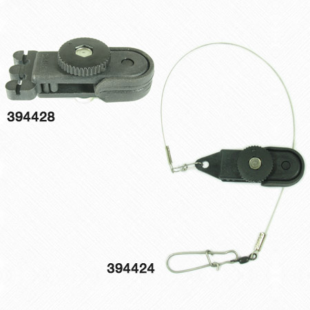
This is how I do a tethered drift launch at Rooster:
macgruber
Since 06 Dec 2011
339 Posts
SE PDX volcano
Obsessed
CGKA Member
PostWed Jun 01, 16 8:11 am fishing clip for drift launch Reply with quote Edit/Delete this post
I got this idea from Puget Sound kiters who use it off of bouys. I attached it to the far west piers since the line in front of the ranger station had a lot of willow bushes. I roll up my lines up above and clamp the fishing clip onto the bridle lines close to the leading edge (the pump attachment point or a few inches of line off of it might work too). The kite stays quiet and you can walk your lines back at your leisure. When you've checked them visually, you simply give the kite a pull and the clip releases it.
Water was about waist deep = 1 foot below crossbar on the pier dams. I went up to the sand island and did see that there is good sand to launch from on the channel beach (walkable from the east end parking). No beach yet straight North from the east end parking.
|
|
|
macgruber

Since 06 Dec 2011
490 Posts
SE PDX volcano
Obsessed
|
 Tue Mar 21, 17 6:44 pm Tue Mar 21, 17 6:44 pm |
 |
|
Here's a pic of the downrigger fishing "release". They are less than $10. I like this thumbwheel type so you can set the tension high
 |
| |
IMG_0496.JPG |
|
|
|
windfun7
Since 23 Aug 2015
40 Posts
|
 Tue Mar 21, 17 7:15 pm Tue Mar 21, 17 7:15 pm |
 |
|
| On a related note does anyone know if the event site sandbar is exposed or how much underwater it is thx
|
|
|
Sasquatch

Since 09 Mar 2005
2086 Posts
PNW
Bigfoot
|
 Tue Mar 21, 17 8:21 pm Re: High water Rooster launch? Tue Mar 21, 17 8:21 pm Re: High water Rooster launch? |
 |
|
| bobgatpdx wrote: | Looks good on RoosterCam today, but the pole is almost submerged.
Anyone have tips for early season launching/landing at Rooster?
- Bob |
Cam seemed to be down today. . .
|
|
|
zipperline
Since 02 Aug 2005
66 Posts
Hood River
|
 Tue Mar 21, 17 8:47 pm Tue Mar 21, 17 8:47 pm |
 |
|
Sandbar Underwater today. Only going to get worse.. Lots of snow melt coming from all directions this spring..
I predict no sandbar until July.. going to be a shit show in town this spring summer.
Oh and Rufus will be class 5 until mid late summer..
Not trying to be a buzzkill but I have lived here 25 years and it has not snowed rained like this for quite some time.....
Breaking swell on the river like in the good old days..... Fend for yourself and figure out a way to access the river...
|
|
|
Hazard to Navigation
Since 12 Sep 2016
62 Posts
Hood River
|
 Wed Mar 22, 17 9:36 am Wed Mar 22, 17 9:36 am |
 |
|
I'm in Hood River, and when we kited on Saturday the water was just about up to the grass. The highest point of the sandbar was maybe 2-4" under water. I'm not sure how far under the picnic table was (I wonder how well anchored it is?). I may try again this afternoon if we get some wind.
There's no visible sandbar at all at Lyle now (not that anyone kites there).
|
|
|
wylieflyote

Since 30 Jun 2006
1647 Posts
Puget Sound & Wa. Coast
XTreme Poster
|
 Wed Mar 22, 17 12:18 pm Wed Mar 22, 17 12:18 pm |
 |
|
| Hazard to Navigation wrote: | | IThe highest point of the sandbar was maybe 2-4" under water. I'm not sure how far under the picnic table was (I wonder how well anchored it is?). |
Anybody's guess if the White Salmon sandbar will withstand this flushing?
_________________
CGKA Member
-------
Kip Wylie |
|
|
voy-tech

Since 08 Apr 2014
372 Posts
Seattle
Obsessed
CGKA Member
|
 Wed Mar 22, 17 12:37 pm Wed Mar 22, 17 12:37 pm |
 |
|
I just hope we won't loose the sandbar completely in the process of intensified erosion that's happening now and it re-emerges when the water level drops 
After all Hood River sandbar was created years ago by the river and could very well be one day destroyed by it.
|
|
|
Sasquatch

Since 09 Mar 2005
2086 Posts
PNW
Bigfoot
|
 Wed Mar 22, 17 4:29 pm Wed Mar 22, 17 4:29 pm |
 |
|
| voy-tech wrote: | I just hope we won't loose the sandbar completely in the process of intensified erosion that's happening now and it re-emerges when the water level drops 
After all Hood River sandbar was created years ago by the river and could very well be one day destroyed by it. |
The high waters reminds me of my early days of kiting in '04 when there was no sand bar. All there was was the jetty on the west end of the Hood River. Limited space to pump up ones kite (wind shadowed area created by the jetty just North of the kite spit/parking lot. We had to run out lines on this gravel ramp that lead up to the parking area and where some kite school are these days. Basically it was more like Stevenson launch (one kite in and one kite out at a time). Then came the big floods of '06, I think. All the material came from the Hood River (about 26 acres worth).
I'm sure the sand bar will be affected by the strong Columbia current to some extent, but it is somewhat protected as the main force and flow of the river is North of the sandbar, more so by the Washington end. So I'm saying it will still be there when the river drops. . . I'm guessing and saying the waters around Wells Island will be even more shallow with sediments from both the event site sand bar and the White Salmon sand bar.
|
|
|
Justsmile

Since 20 Jul 2009
1527 Posts
Not Portland
XTreme Poster
|
 Wed Mar 22, 17 4:44 pm Underwater bar! Wed Mar 22, 17 4:44 pm Underwater bar! |
 |
|
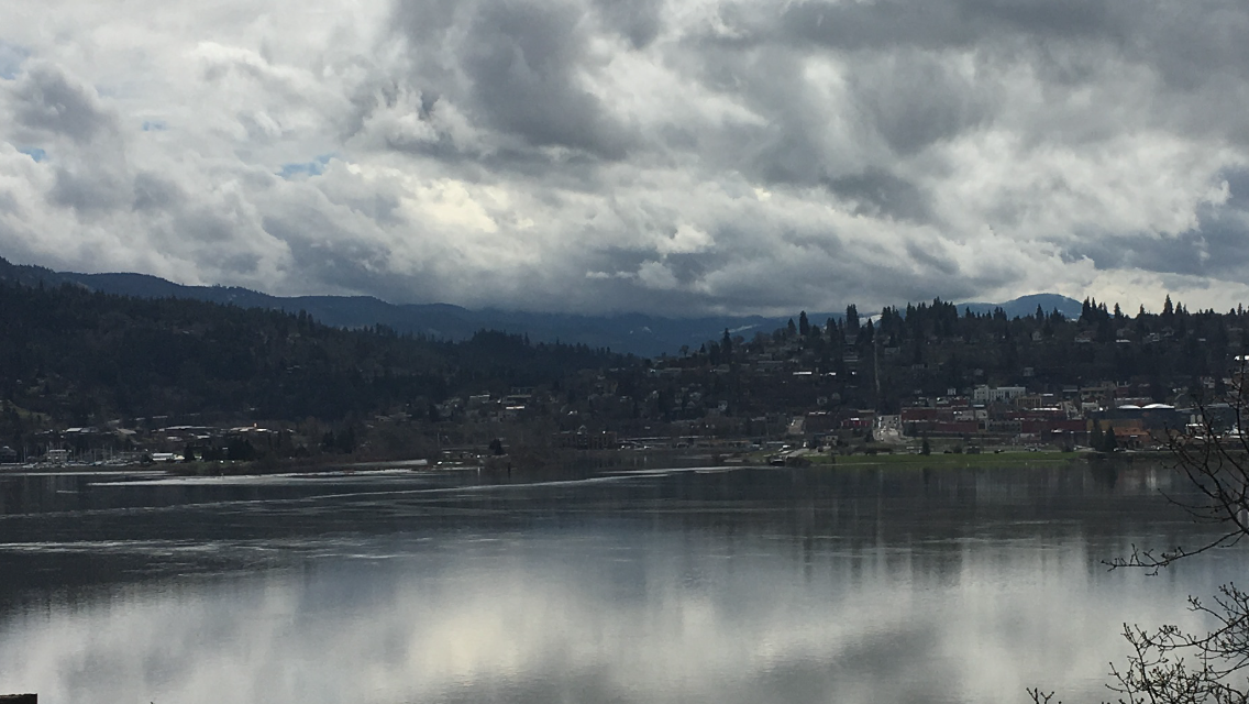
Pic of the underwater bar:-) !!!
 |
| |
IMG_1655.PNG |
_________________
Take a breath; inhale |
|
|
airon^
Since 07 Aug 2013
290 Posts
Durango
Obsessed
|
 Thu Mar 23, 17 9:37 am underwaterbar Thu Mar 23, 17 9:37 am underwaterbar |
 |
|
The other thing is that the erosion will be significant and long lasting (well into July) on the Hood River so that should replace some of the sand flushed away by the high Columbia.
_________________
surf the san juans |
|
|
|


