|
previous topic :: next topic |
| Author |
Message |
bigjohn
Since 13 Mar 2012
663 Posts
Addicted
|
 Thu Apr 23, 15 4:10 pm Calling wind gurus - Why did this happen Thu Apr 23, 15 4:10 pm Calling wind gurus - Why did this happen |
 |
|
To all you wind gurus out there.
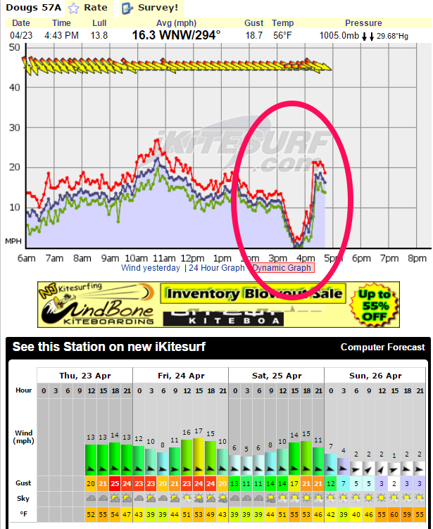
A weird thing happened at Dougs Beach today. The wind completely dropped to nothing for about 45 minutes. I would like to try to understand why (and ultimately learn how to recognize before it happens).
Some of the symptoms that I find interesting are:
1) Human forcasts placed Dougs beach as the best place to kite today.
2) Computer forcasts placed Dougs beach as very good kiting today.
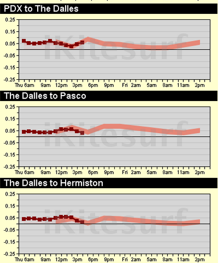
3) Pressure Reports from Portland to Hermiston/Pasco were good and in line with forcasts.
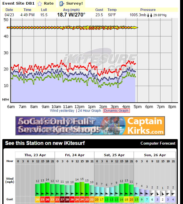
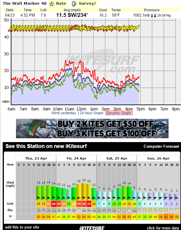
4) Neither Hood River nor Rufus experienced this dead wind period.
5) There were clouds over Dougs beach all afternoon. i.e. the cloud cover did not vary much from when there was wind to when the wind droped off.
Any ideas?
 |
| |
dougsbeachgraph.png |
 |
| |
Pressure Report.png |
 |
| |
Event Site graph.png |
 |
| |
The Wall Graph.png |
_________________
Kiting starts at 40MPH |
|
|
Gman

Since 11 Feb 2006
4907 Posts
Portland
Unstrapped
|
| Thu Apr 23, 15 5:28 pm |
|
|
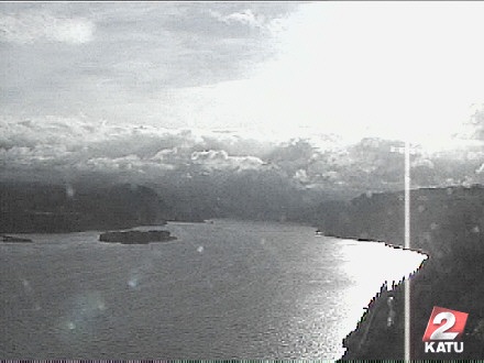
Not rocket science - cloudy unsettled weather
Can drop out completely or go richter - when the clouds look like a blast wall downriver (like now) can get exciting
 |
| |
image.jpg |
_________________
Go Deep!
https://m.youtube.com/watch?v=eu2pBpQolKE |
|
|
bigjohn
Since 13 Mar 2012
663 Posts
Addicted
|
| Thu Apr 23, 15 6:27 pm |
|
|
Perhaps, however I did not notice the clouds being all that extreme, also did not notice much of a variance between the windy time and the drop off time.
I would say there were approximately 40% cumulus clouds all day, with 90% total cloud coverage if you include altostratus and cirrus clouds.
I did not notice a major storm as your cam picture reflects.
Are you suggesting that even though I couldn't see the clouds (by Hood River), they might have been impacting the wind at Dougs?
_________________
Kiting starts at 40MPH |
|
|
lloyd
Since 16 Aug 2007
108 Posts
Hood River
Stoked
|
| Thu Apr 23, 15 7:21 pm |
|
|
| Yes, the clouds....... Even clouds North or South of the river can effect the pressure gradients.
|
|
|
CrazyHerb

Since 04 Oct 2008
79 Posts
Ilwaco, WA
|
| Thu Apr 23, 15 8:41 pm |
|
|
Check out what we got here at the coast...talk about slamming the door!
Looks like it just moved inland and gave you a taste shortly after.... 
Shrug...typical unstable Spring I guess...

|
|
|
Aeolus

Since 20 Apr 2010
354 Posts
Gold Beach, OR
OR-SoCo-Aficionado
|
| Thu Apr 23, 15 9:24 pm |
|
|
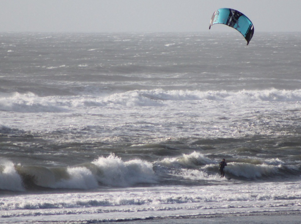
I mostly look at the calendar to see if we are still residing in the month of April. Memorable beat downs have happened to me in this month. Mostly from abrupt, unsettled hatefulness. Like yesterday. Cloud line at beach/town interface. Kite falls out of sky 3 times during gale. Get annihilated by shore pound in front of hotel guests. 
I think if you launch your kite anywhere in the pacNW in April, all bets are off.
Clouds  
 |
| |
image.jpg |
|
|
|
Windian

Since 28 Apr 2008
881 Posts
Newport, OR
NEWPORT OG
|
| Thu Apr 23, 15 9:46 pm |
|
|
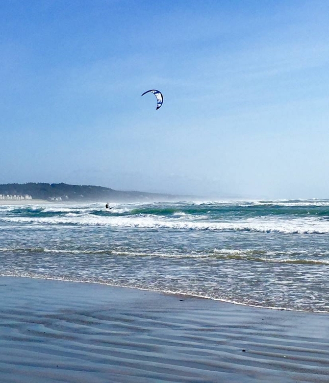
It has been big, burly and beautiful lately around central coast.
 |
| |
11159456_10200566648643976_3999445139630741047_n (645x750).jpg |
|
|
|
bigjohn
Since 13 Mar 2012
663 Posts
Addicted
|
| Fri Apr 24, 15 6:23 am Wind Safety Guideline |
|
|
Okay, so here's what I have so far.
Guideline:
If computer models and human forcasts are in alignment with each other, however not in alignment with actual winds then you should be aware that other factors are affecting the wind. Specifically that clouds (somewhere, and not necessarily visible within region) are creating pockets of disparity throughout the Gorge. Also, if it is the month of April, the probability of these pockets increases tremendously.
So, if you are kiting and the above guideline applys, in the event winds start getting light, you should be looking for a possible landing location under the expectation that the wind might completely shutdown for periods of up to an hour.
_________________
Kiting starts at 40MPH |
|
|
ldhr
Since 21 Jul 2009
1471 Posts
Hood River
XTreme Poster
|
| Fri Apr 24, 15 7:49 am |
|
|
bigjohn - the wind was out of the North - expect wild fluctuations on the river when the wind is out of the North.
the wind is usually better when it's west or wsw.
if it's extreme NW or SW these anomalies are more likely to occur.
also- a few years ago the Dougs sensor would look this way all the time. I think it was caused by a large bird/hawk that sat on top of the wind sensor.
either that or the phone/internet connection would drop for a few minutes making it look like the wind dropped.
|
|
|
moondog
Since 15 Aug 2007
698 Posts
white salmon
Addicted
CGKA Member
|
| Fri Apr 24, 15 7:58 am |
|
|
The weird part of your scenario is the winds died right when they clocked to the west. very unusual. Apr and Sep are the two months when the bottom can fall out in the gorge. The problem with Apr. is the swim is mighty cold back to the shore!
_________________
moondog |
|
|
bigjohn
Since 13 Mar 2012
663 Posts
Addicted
|
| Fri Apr 24, 15 8:39 am |
|
|
I can confirm that the sensor was correct. The wind went completely dead. Not a ripple in the water during this time. No possible way to keep kite in the air.
_________________
Kiting starts at 40MPH |
|
|
bigjohn
Since 13 Mar 2012
663 Posts
Addicted
|
| Fri Apr 24, 15 8:43 am |
|
|
Also, I don't think I described the scenario very well in my initial post, however the reason I felt this particular event deserved further analysis was because the normal warning signs were not present.
When a storm front comes through (very dark cumulus clouds with rain etc.) you expect wind like this. However in this situation the warning storm clouds were not present.
_________________
Kiting starts at 40MPH |
|
|
bigjohn
Since 13 Mar 2012
663 Posts
Addicted
|
| Fri Apr 24, 15 9:33 am |
|
|
| moondog wrote: | | The weird part of your scenario is the winds died right when they clocked to the west. very unusual. Apr and Sep are the two months when the bottom can fall out in the gorge. The problem with Apr. is the swim is mighty cold back to the shore! |
Adding to this analysis... The Dougs 57A sensor very very rarely reads west. It almost always clocks from NW to NNW.
I should also add that my vantage point of the clouds at the time was from SS to Lyle looking North. Thus I could not see cloud systems to the South or East.
_________________
Kiting starts at 40MPH |
|
|
fredf
Since 10 Jan 2009
80 Posts
Eugene. Or
|
| Fri Apr 24, 15 10:33 am |
|
|
An associated question is where does that wind go when it drops precipitously in one stretch of the Gorge but is blowing like stink up-river or down or both?
I suppose the only place it can go is higher and off the water and then back down where it is blowing.
Strange indeed but it shows that rarely is the Gorge a wind "tunnel".
|
|
|
bigjohn
Since 13 Mar 2012
663 Posts
Addicted
|
| Fri Apr 24, 15 12:49 pm |
|
|
Which makes me think of another observation I have never understood.
At Dougs Beach, clouds usually come from the SouthWest direction while the wind comes from the NorthWest direction.
At Rufus, Wind towers are always pointing towards the North, but if you ride up to the wall, the wind tends to come from a more southerly direction (at least compared to the wind towers).
Things that make you go HUH?
_________________
Kiting starts at 40MPH |
|
|
gtm
Since 04 Jul 2005
35 Posts
|
| Sat Apr 25, 15 7:15 am |
|
|
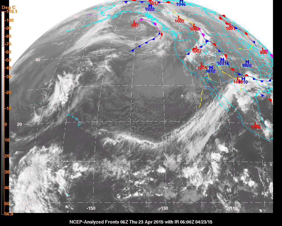
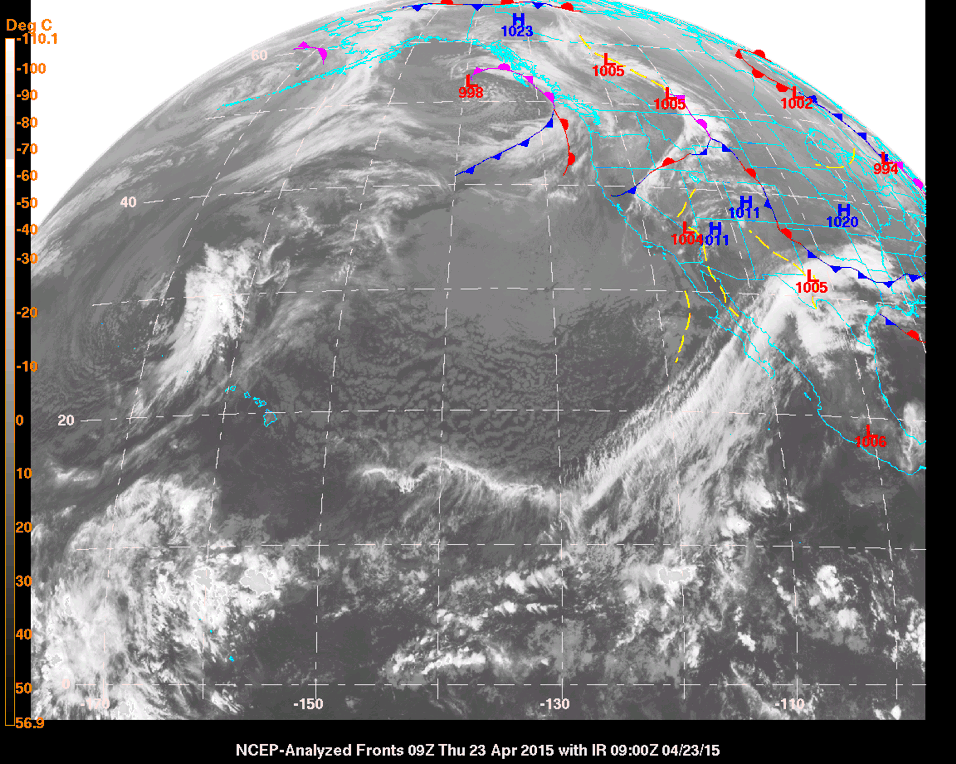
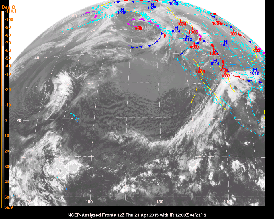
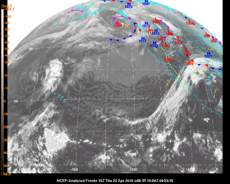
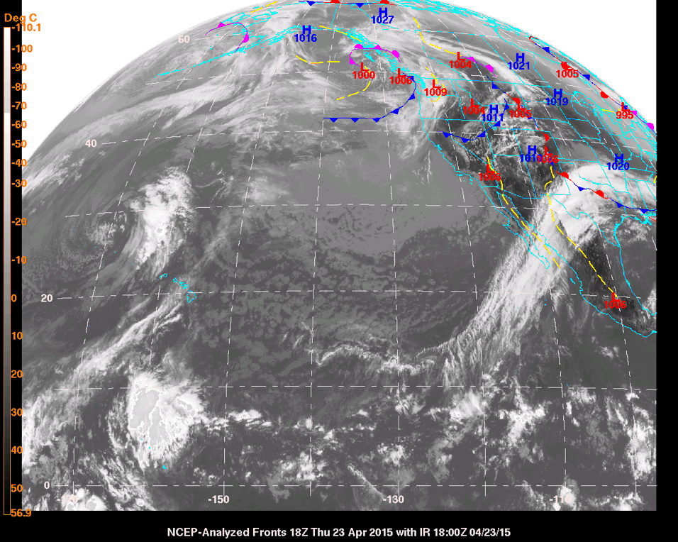
Spring wind in The Gorge can be challenging as many have already stated. The complex terrain that sets up the nice gap flow in the summer can create really erratic wind in the spring when the wind is more influenced by stronger weather systems.
In hindsight it looks like there was a trough off the BC coast that day that was slowly moving inland. Often these troughs have disturbances that rotate around the base of the trough and can kick inland head of the trough. These disturbances act like small scale cold fronts and are often referred to as short waves (short wavelength compared to large scale systems). There is usually a wind shift as these short waves pass through. They can also disturb any gap flow as they move through.
The Cape Disappointment plot above shows a classic pattern for a short wave moving through with strong south wind ahead of the front and a clear wind shift to the NW after the short wave. As the short wave crosses the gorge the terrain adds friction and makes the frontal passage much less obvious but a shift to west at Doug's from NW shows some kind of disturbance moved through.
Of course the real problem is forecasting this ahead of time. Nailing a forecast of when this wave moves through and how much it affect the wind at a given sight would be difficult. All I could say with any confidence is that when the weather maps show a short wave moving through the region, it will be up and down.
|
|
|
bigjohn
Since 13 Mar 2012
663 Posts
Addicted
|
| Sat Apr 25, 15 8:42 am |
|
|
Based upon what GTM stated, I did a little research. I borrowed some satellite graphics from U of W atmos program of weather events for 4/23.
The graphics are in the order:
6:00am, 9:00am, noon, 3:00pm, 6:00pm.
They appear to back up exactly what GTM stated. I find this all interesting... Just trying to figure out how it might make me a safer kiter. 
 |
| |
6amSatelliteResized.gif |
 |
| |
9amSatelliteResized.gif |
 |
| |
12amSatelliteResized.gif |
 |
| |
3pmSatelliteResized.gif |
 |
| |
6pmSatelliteResized.gif |
_________________
Kiting starts at 40MPH |
|
|
|