 |
|
|
previous topic :: next topic |
| Author |
Message |
sromano1995

Since 22 May 2013
240 Posts
Portland
Stoked
|
 Tue Jul 22, 14 4:59 pm HR Danger Map Tue Jul 22, 14 4:59 pm HR Danger Map |
 |
|
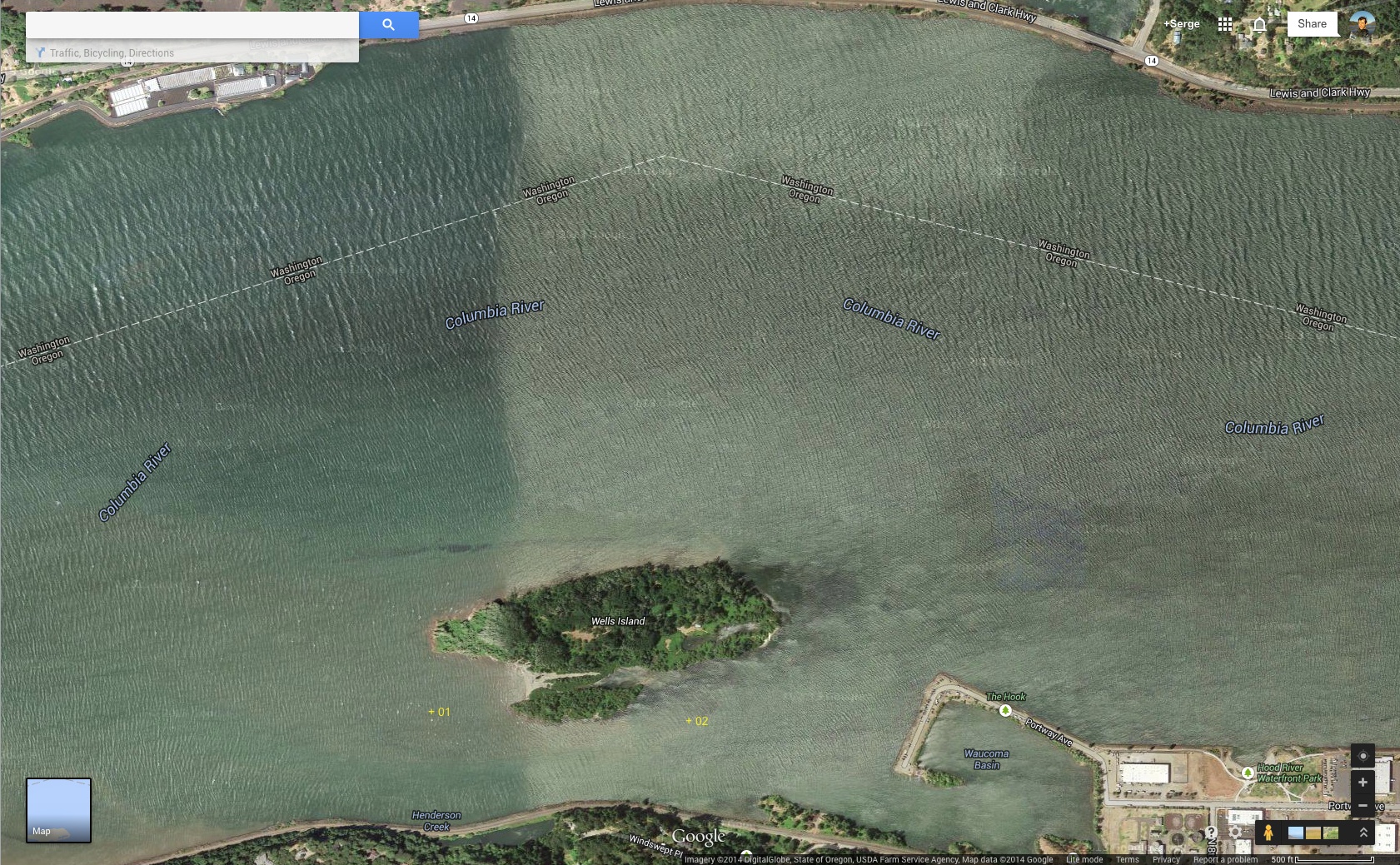
In the last couple of weeks of riding around Wells Island, I ran into a couple of obstacles / logs hidden below the water line. Luckily, I did not damage or break anything but it was obvious that these obstacles could present real dangers to watercraft and/or kiters.
In both cases it was clear that these logs / pilings could not be easily removed and marking was the only short term option to ensure safety. It also appeared that these obstacles had been marked in the past as ropes were attached to them. However, the markers were gone.
I was wondering if any efforts had been undertaken in the past to create and share a map of such obstacles around the HR area (Wells, White Salmon, Sandbar, Marina, etc...). While markers may disappear from one year to the next, on some of these obstacles may move, having a map that gets refreshed by the community of people riding these waters on a daily basis could be quite useful.
A thread on this topic in this forum could be an option but there may be other web technologies out there to create such dynamic / interactive maps. If anybody else thinks this could be a good idea and/or have suggestions, I believe it would be worth pursuing.
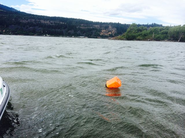
In addition to mapping, marking seems like the best option to prevent accidents. I created a couple of simple/cheap markers (with milk bottles, painted inside with bright orange paint and filled with foam) that I now carry with me on my jet ski in case I ran into such new obstacle and I marked one that presented the most immediate danger to kiter on Wells Island. I really don't like to idea of putting plastic junk in the river but, in this case, I think the benefits outweigh the risk to the environment. Also interested in ideas on this topic and whether there are rules / regulations on this issue.
Below is the start of map with the position of the two underwater logs/pilings mentioned above. 01 is the one that I marked. Next time, I am in the area I will try to mark 02.
 |
| |
HR Wells Danger Map.jpg |
Last edited by sromano1995 on Wed Jul 23, 14 7:41 am; edited 3 times in total |
|
|
sromano1995
Since 22 May 2013
240 Posts
Portland
Stoked
|
| Tue Jul 22, 14 5:13 pm Wells Marker 01 |
|
|
The obstacle (marker 01 in the map above) below is BELOW the water line even at low water level making it specifically dangerous considering that it is a kiteable area of the island in the shallow part. I ran into it with the jet ski while the water level of the river was quite low on an early Sunday morning two weeks ago. With branches poking it under the water, I can't imagine falling on it while riding. See two pics below for position with respect to island. The marker should help to avoid it.
 |
| |
IMG_3483-medium.jpg |
 |
| |
IMG_3484-medium.jpg |
|
|
|
chrissmack

Since 08 Jun 2005
515 Posts
portland
Addicted
|
| Tue Jul 22, 14 5:41 pm |
|
|
| monkeyboy, get on it!! make the danger map!!
|
|
|
Wind Slither

Since 04 Mar 2005
2575 Posts
The 503
METAL
|
| Wed Jul 23, 14 4:15 am |
|
|
What we need... is a HR Dangler Map! 
 |
| |
danger.png |
|
|
|
moondog
Since 15 Aug 2007
698 Posts
white salmon
Addicted
CGKA Member
|
| Wed Jul 23, 14 7:58 am |
|
|
Good heads up post. There are also 2 stumps/logs on the N side of Wells Island 20 yards out towards the west end that are very difficult to see when the water is high.
The Wunderbar has 4 major stumps 50 yards out just below the surface right now. I marked 3 of them last year, but all the buoys are missing this year. I watched some kids release one last year. I cringe every time I see unknowing kiters come in and show off all their latest moves, not knowing what is lurking just underneath the water. It also has a sunken log (ankle breaker} 3 yards off the the landing zone. When the water is really low there are hundreds of Punji sticks pointing straight up to impale kites, feet or boards, so come in SLOW.
I'm torn this year with marking all of these hazards because of the incident earlier this season with the kiter who got wrapped around the green channel marker. Two weeks ago I saw another kiter wrapped around the red channel marker near the hatchery. My kite fell out of the sky in the wind shadow at the Wunderbar and wrapped around one of the stump buoys I installed. With the very strong current it was impossible to release my lines. I came back in a kayak 2 days later and cut the buoy free to get my bar and lines. The water is 45 degrees in that area by the way.
I like the idea of a map like the one above to depict all the hazards, since marking them with buoys is a hazard in itself.
_________________
moondog |
|
|
Sol-flyer

Since 21 Mar 2006
1280 Posts
Dude, where's my Bus?
Otto Mann
|
| Wed Jul 23, 14 8:32 am |
|
|
Can't say I'm a fan of more floating garbage on the river...as if the fish nets weren't bad enough. I think having an awareness that there is potential debris is more effective than trying to mark every log and stick and rock we come across.
_________________
I stretch my wings and pull the strings |
|
|
PieroPDX

Since 22 May 2006
109 Posts
Stoked
|
| Wed Jul 23, 14 9:08 am |
|
|
Who is going to consult a map while they are on the river at top speed in case there is a hazard in their path...? What about visitors who have no idea about a map?
In the future we'll have visors with augmented reality markers that point out obstacles in real-time... Until then, markers are the most effective approach I would think.
It's not garbage if it's a buoy marking a hazard, and I'd think that it's more than justified to save kiters from serious injury or death.
Maybe we should organize a session to go out and mark hazards?
We might even get local kite businesses to sponsor hazard markers with their logos on them, lol.
_________________
If you're in PDX hit me up, I'm looking to meet kiters in town. I'm close in NW. |
|
|
kitezilla

Since 22 Jun 2006
453 Posts
gorge
Obsessed
|
| Wed Jul 23, 14 9:52 am |
|
|
A few years ago, I wrote this in the thread:
http://www.nwkite.com/forums/t-4070-0-asc-51.html
Some of this lengthy comment may apply to the subject under discussion. I have one more thought as a result of what I witnessed down at SPI a few years ago, when the oil and gas exploration company decorated the shallow bay with a gazillion 3/4 inch PVC markers, sticking about 5 feet out of the water, showing the location of their sounding devices. These white poles were very intimidating looking, but after a while (and a number of incidents of smashing into and catching lines on the pipes), we found out that the PVC pipes were not such a hazard, in that, they would bend and shed the lines, and when we smashed into them they would bend and not impale the kiter (but the potential still existed for this). Sooooo, maybe something like a PVC half-inch pipe, sticking up, with a green tennis ball on top would be the safest kind of marker. Some kind of base, supporting the pipe, like the round weighted base, that secures a beach umbrella to the patio
would tip over and come back upright, like a punching dummy
Anyhoooo, for what its worth:
"
The subject of marker buoys, and signs may deserve more discussion and planning than is immediately apparent. Three issues need to be well thought out in advance of any actions:
(1) Boundary Marking Buoys
(2) Hazard Marking Buoys
(3) Signage
Precautions concerning buoy construction and placement:
(A) Follow the administrative rulings and codes
(B) Avoid making a bad situation worse by creating an additional hazard
As far as (A) goes, I think we will quickly find that there will be at least one governmental body or administrative authority which will jealously guard its right to control signage and marker placement. This is a common bureaucratic problem, stemming from liability and responsibility issues, and is not all bad, but does present expense and delay problems. We need to identify the administrative body immediately, and start working with that authority, in order to present the unique problems that pertain to the recreational activity of kiteboarding. For instance, consider the international character of kiting, so, do the signs need to be tri-lingual? Do we need signs actually located on the water, or just on dry land? Will the markers be colored properly, so as not to confuse commercial navigation, or Native American fishermen, or other water sport recreationalists?
As far as (B) goes, I think we could do everyone a big service by helping to plan the construction of the (1) and (2) buoys, so that they are kite-line-friendly. This may be a challenge! I have some ideas, and hopefully others will have some even better ideas. The overriding principle should be to have a buoy safely constructed in such a way that a kite line will slip off the buoy, rather than snag on some feature or the buoy and to have the buoy constructed of a soft and forgiving material, which will harmlessly absorb human impact, and move out of the way.
Consider:
A smurf-like buoy
A foam wand style buoy
A buoy shaped larger at the bottom than at the top, with smooth curves, to shed kite line, and fishing line
A UV resistant buoy durable enough for the wind, waves, floating debris, boats and free floating fishing line and lures of the Columbia River
A design that can be serviced by a designated authority, and who the authority should be
The (2) hazard marking buoys as well as the (1) boundary buoys should incorporate the above safety principles. The (2) buoys will be needed to mark the submerged hazards, such as the sand imbedded logs. These buoys will always be located in shallow water, and will have the deadhead as an anchoring device. These markers should be designed so that they definitely do not capture a kite line. Imagine a snagged rear line throwing a kite into power-zone loops and towing a kiter head-first straight into the deadhead.
Anyways, lets put some thought into this, and avoid placing a hazard into our little war zone."
http://www.nwkite.com/forums/t-4070-0-asc-51.html
|
|
|
kitezilla
Since 22 Jun 2006
453 Posts
gorge
Obsessed
|
| Wed Jul 23, 14 9:56 am |
|
|
A few years ago, I wrote this in the thread:
http://www.nwkite.com/forums/t-4070-0-asc-51.html
Some of this lengthy comment may apply to the subject under discussion. I have one more thought as a result of what I witnessed down at SPI a few years ago, when the oil and gas exploration company decorated the shallow bay with a gazillion 3/4 inch PVC markers, sticking about 5 feet out of the water, showing the location of their sounding devices. These white poles were very intimidating looking, but after a while (and a number of incidents of smashing into and catching lines on the pipes), we found out that the PVC pipes were not such a hazard, in that, they would bend and shed the lines, and when we smashed into them they would bend and not impale the kiter (but the potential still existed for this). Sooooo, maybe something like a PVC half-inch pipe, sticking up, with a green tennis ball on top would be the safest kind of marker. Some kind of base, supporting the pipe, like the round weighted base, that secures a beach umbrella to the patio
would tip over and come back upright, like a punching dummy
Anyhoooo, for what its worth:
"
The subject of marker buoys, and signs may deserve more discussion and planning than is immediately apparent. Three issues need to be well thought out in advance of any actions:
(1) Boundary Marking Buoys
(2) Hazard Marking Buoys
(3) Signage
Precautions concerning buoy construction and placement:
(A) Follow the administrative rulings and codes
(B) Avoid making a bad situation worse by creating an additional hazard
As far as (A) goes, I think we will quickly find that there will be at least one governmental body or administrative authority which will jealously guard its right to control signage and marker placement. This is a common bureaucratic problem, stemming from liability and responsibility issues, and is not all bad, but does present expense and delay problems. We need to identify the administrative body immediately, and start working with that authority, in order to present the unique problems that pertain to the recreational activity of kiteboarding. For instance, consider the international character of kiting, so, do the signs need to be tri-lingual? Do we need signs actually located on the water, or just on dry land? Will the markers be colored properly, so as not to confuse commercial navigation, or Native American fishermen, or other water sport recreationalists?
As far as (B) goes, I think we could do everyone a big service by helping to plan the construction of the (1) and (2) buoys, so that they are kite-line-friendly. This may be a challenge! I have some ideas, and hopefully others will have some even better ideas. The overriding principle should be to have a buoy safely constructed in such a way that a kite line will slip off the buoy, rather than snag on some feature or the buoy and to have the buoy constructed of a soft and forgiving material, which will harmlessly absorb human impact, and move out of the way.
Consider:
A smurf-like buoy
A foam wand style buoy
A buoy shaped larger at the bottom than at the top, with smooth curves, to shed kite line, and fishing line
A UV resistant buoy durable enough for the wind, waves, floating debris, boats and free floating fishing line and lures of the Columbia River
A design that can be serviced by a designated authority, and who the authority should be
The (2) hazard marking buoys as well as the (1) boundary buoys should incorporate the above safety principles. The (2) buoys will be needed to mark the submerged hazards, such as the sand imbedded logs. These buoys will always be located in shallow water, and will have the deadhead as an anchoring device. These markers should be designed so that they definitely do not capture a kite line. Imagine a snagged rear line throwing a kite into power-zone loops and towing a kiter head-first straight into the deadhead.
Anyways, lets put some thought into this, and avoid placing a hazard into our little war zone."
http://www.nwkite.com/forums/t-4070-0-asc-51.html
|
|
|
DownStream
Since 18 Apr 2007
381 Posts
Obsessed
|
| Wed Jul 23, 14 10:08 am |
|
|
is that what those pvc's were for? I collected tons of those (everyone I could rip out of the ground with the jetski that wasn't too covered in barnacles)
_________________
PROKITE LESSON CENTER
SOUTH PADRE ISLAND
541 490 6872
www.ProKiteLessons.com
info@prokitesouthpadre.com |
|
|
A.K.
Since 01 Jul 2006
190 Posts
Stoked
|
| Wed Jul 23, 14 12:12 pm |
|
|
It is important for hazards to be marked. In the past - seasoned locals or instructors from kite schools have proactively taken it upon themselves to mark the hazards with a small milk jug and rope.
An opaque plastic bottle or other subtle color will suffice - without marring up the perfect views.
Thanks for taking the effort to go out and mark the hazard.
-A.K.
|
|
|
Gman

Since 11 Feb 2006
4907 Posts
Portland
Unstrapped
|
| Wed Jul 23, 14 12:18 pm |
|
|
| A.K. wrote: | mark the hazards with a small milk jug and rope.
-A.K. |
Fairly standard worldwide among boaters/ not interested in wrecking an outboard motor
_________________
Go Deep!
https://m.youtube.com/watch?v=eu2pBpQolKE |
|
|
ldhr
Since 21 Jul 2009
1472 Posts
Hood River
XTreme Poster
|
| Wed Jul 23, 14 1:45 pm |
|
|
slippery slope..... who decides what is a hazard?
next up - let's remove all the rocks and pad the trees in Post Canyon mountain bike trails?
Put pads on the trees in Jacks Woods.
I say let Darwin and natural selection take it's course.
|
|
|
PieroPDX
Since 22 May 2006
109 Posts
Stoked
|
| Wed Jul 23, 14 2:04 pm |
|
|
(Chuckle) ...while I'm a huge fan of Darwin awards, I'm not so sure this is the classic definition of a slippery slope.
Based on that philosophy.... Let's erase lane lines on roads and just let people figure it out. And why bother with air traffic controllers? 
Everything could be a slippery slope by that definition. And they can go both ways, with almost everything in life... but we still choose to have safety standards for automobiles. 
Just off the top of my head, it seems rather straightforward: A hazard is a submerged (cannot see) object, near the surface at highest and/or lowest water levels... that would hurt or kill you if you hit it at high speeds.
_________________
If you're in PDX hit me up, I'm looking to meet kiters in town. I'm close in NW. |
|
|
willhf
Since 03 Jul 2014
26 Posts
|
|
|
kitezilla
Since 22 Jun 2006
453 Posts
gorge
Obsessed
|
| Thu Jul 24, 14 8:05 am |
|
|
Seems like there is always "SEAWEED" in the shallow water, where the "deadheads" rest on the bottom. I could see seaweed getting bound up in the "spokes". Seaweed accumulation can even sink a clorox bottle. Always something...
Clever idea though!
 |
| |
mine-cable-passer.jpg |
|
|
|
Sasquatch

Since 09 Mar 2005
2060 Posts
PNW
Bigfoot
|
| Thu Jul 24, 14 9:14 am |
|
|
| Wind Slither wrote: | | What we need... is a HR Dangler Map! |
INDEED, a Dangler map is in need of an update. "Starboard!"
|
|
|
|
|
You cannot post new topics in this forum
You cannot reply to topics in this forum
You cannot edit your posts in this forum
You cannot delete your posts in this forum
You cannot vote in polls in this forum
You can attach files in this forum
You can download files in this forum
|
|

