|
previous topic :: next topic |
| Author |
Message |
moondog
Since 15 Aug 2007
698 Posts
white salmon
Addicted
CGKA Member
|
 Thu Nov 10, 11 6:26 pm The new White Salmon sandbar Thu Nov 10, 11 6:26 pm The new White Salmon sandbar |
 |
|
Kayaked up the WS today from the Columbia. Do you want the good news or the bad news first? If your are a Native American, your in lieu access is unusable. If you are a salmon fisherman your WS pool is now a huge sandbar for a half a mile upstream. There is a prodigious quantity of sediment that has filled in the pool North of the bridge. Water depth used to be 20 ft. It is now 0-3 ft. If you are a kiteboarder their is a sandbar forming South of the bridge on both sides, favoring the west side. The fishing bench on the west side used to be 20 ft deep next to the wall. It is now 3 inches.
I paddled across the entire mouth checking depths on the south side of the bridge and found water depths ranging from 3 inches to 3 feet. It was normally 20-30 ft.
When the winter rains show up, everything could change. One thing is for sure, it is a very fluid situation with changes every day. Pun Intended!!!! I forecast a small sandbar on the west side of the bridge next spring extending out about 50 yards, because of the east eddy in the area. This is a major event, every day I go explore there are either scientist or reporters on the scene!!!
_________________
moondog |
|
|
kitezilla

Since 22 Jun 2006
453 Posts
gorge
Obsessed
|
| Fri Nov 11, 11 6:49 am |
|
|
Thanks for the report.
The depth of the water around the old pilings at the bottom of what used to be an old access road, ending about a hundred yards west of the mouth of the WS river... was always quite shallow.
My question is: "Did a lot of the silt pile up around those old pilings?"
|
|
|
wylieflyote

Since 30 Jun 2006
1634 Posts
Puget Sound & Wa. Coast
XTreme Poster
|
| Fri Nov 11, 11 7:15 am |
|
|
And my question for you hydrologists is: Any thoughts on whether the added silt and change in depth at the bridge will cause for better swell sets on the Columbia River? Or maybe higher flow rates from the White Salmon will create bigger swell in our playground?
_________________
CGKA Member
-------
Kip Wylie |
|
|
nickdward

Since 11 Aug 2008
130 Posts
Seattle
Stoked
|
| Fri Nov 11, 11 7:23 am |
|
|
Yes Kip, I'd say the swell near White Salmon will be 157% better next summer.
_________________
"all I need are some tasty waves, a cool buzz, and I'm fine."
My Blog: http://straplesskitesurf.blogspot.com/ |
|
|
Pepi

Since 16 Jun 2006
1831 Posts
Pure Stoke Sports
Shop Owner
CGKA Member
|
| Fri Nov 11, 11 10:35 am |
|
|
| wylieflyote wrote: | | And my question for you hydrologists is: Any thoughts on whether the added silt and change in depth at the bridge will cause for better swell sets on the Columbia River? Or maybe higher flow rates from the White Salmon will create bigger swell in our playground? |
From what we've all experienced from these past couple of years at the HR Sandbar, I'm sure that we'll just have to see what Mother Nature delivers in the form of rain and water flows.
More rain equals stronger currents to erode away weak shoreline, but can also deliver lots of sediment down rivers when given the right circumstances.
With what Moondog just described to us, it might be a sign that we are still in the middle of the river flushing phase of this scenario.
If most of the sediment stays under water, it will not really settle in and is still very moveable if given enough water currents.
It'll all be very interesting to see play out this winter and spring.
Anyone have any access to aerial photos?
Bam, howabout you take some photos on your next paraglide flight!!
_________________
Pure Stoke Sports
Hood River, OR
http://www.facebook.com/pages/Hood-River-OR/2nd-Wind-Sports/35891485558?ref=mf
www.Purestokesports.com |
|
|
kitezilla
Since 22 Jun 2006
453 Posts
gorge
Obsessed
|
| Fri Nov 11, 11 12:21 pm |
|
|
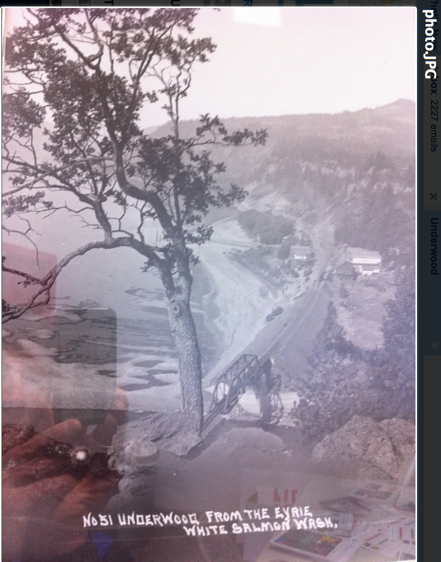
The same place, from which, this picture was taken, would be a good place to start taking pictures... every month or two for the next few years. We would have a reference for comparison of any growth from deposits from the WS.
While we are making bets and hypothesis on the changes which may occur...here's one:
No significant sandbar will form at the mouth of the WS river until some MASSIVE floods occur, which will drive not just sand and gravel and silt down the WS river, but wil drive BOLDERS down the WS river, out into the Columbia. The bolders will then form a foundation on which to eddy out the sand, and on which the sand can accumulate and build. Until the bolder "groin" forms, the Columbia will just wash away any sand and silt that gets washed down the WS river.
It would be interesting to know how much of the sand in the picture, is still there under the water of the Columbia.
 |
| |
mouth WS old photo.png |
Last edited by kitezilla on Fri Nov 11, 11 3:40 pm; edited 1 time in total |
|
|
moondog
Since 15 Aug 2007
698 Posts
white salmon
Addicted
CGKA Member
|
| Fri Nov 11, 11 2:42 pm |
|
|
Senor Kitezilla, where did you find the photo? I know the present owners of old Eyrie Resort so I could take photos when necessary.
_________________
moondog |
|
|
kitezilla
Since 22 Jun 2006
453 Posts
gorge
Obsessed
|
| Fri Nov 11, 11 3:35 pm |
|
|
| moondog wrote: | | Senor Kitezilla, where did you find the photo? I know the present owners of old Eyrie Resort so I could take photos when necessary. |
It was emailed to me through a person who got it by taking a picture of it with someone's phone, I think. That accounts for the weird reflections. I think that the picture is in a museum in the Gorge.
That would be great if you could take some pictures from that exact place. I bet that tree is still right there on the bluff... and probaby hasn't grown too much in the last 80 years.
A lot of structures have come and gone down there, since the picture was taken..."before the roads came in".
|
|
|
apctjb
Since 19 Aug 2007
427 Posts
Obsessed
|
| Fri Nov 11, 11 3:50 pm |
|
|
Cool photo; would love to get a higher res copy.
What fun that sandbar would be for those of us in Underwood...
|
|
|
moondog
Since 15 Aug 2007
698 Posts
white salmon
Addicted
CGKA Member
|
| Fri Nov 11, 11 4:07 pm |
|
|
It might be in the Bingen museum, they have many old photos hanging like a book on the south wall. Yesterday Channel 2 news was at the WS pool interviewing someone from Pacificorp with numerous irate fishermen milling around saying what a disaster this turned out to be. Patience, it has only 2 weeks and no rain!!!
_________________
moondog |
|
|
4Stringer/KipWinger

Since 27 Apr 2005
541 Posts
Hood River
Addicted
|
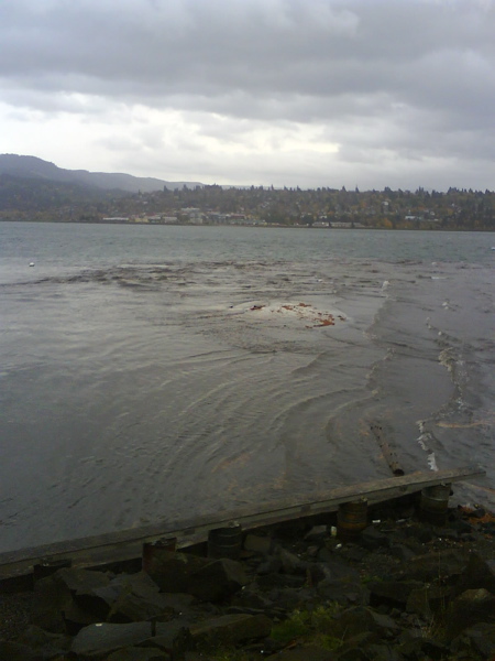
| Sun Nov 13, 11 4:40 pm 11/13/11 sandbar progress |
|
|
As has been said already, it's going to be very interesting to watch the mouth of the White Salmon through winter and into spring. Here's what it looked like on Sunday, 11/13/11. Sandbar is definitely forming, whether is stays or not is difficult to say. But I'll go out on a limb and say that the White Salmon sandbar is gonna stick around. That's to say, Monkeyboy is going to be dead wrong. We'll see. Perhaps some beer oughta' be riding on this call.
 |
| |
WS sandbar.jpg |
_________________
revitalized by muthu-nachu |
|
|
Justsmile

Since 20 Jul 2009
1523 Posts
Not Portland
XTreme Poster
|
| Sun Nov 13, 11 7:17 pm |
|
|
| awesome, keep it growing!!! please mutha nature, please!!!!!
|
|
|
kitezilla
Since 22 Jun 2006
453 Posts
gorge
Obsessed
|
| Mon Nov 14, 11 6:58 am |
|
|
My hope was that the silt would eddy out in the 3 little bays between the Hatchery launch and the fish hatchery buildings... and thereby make a perfect place to get out of the wind shadow, for launching a kite. Any sign of anything happening in any of those bays? If so, can someone take pictures?
Here's a thought: If a real nice sandbar (delta) forms at the mouth of the WS river, then, kiters and fishermen might have some real conflicts, fighting over parking spaces up against the tracks, not to mention what would happen out on the sand bar, so it might be better if a shallow water, submerged sandbar is all that forms. That way, the more devoted kiters could do a shallow water launch (ghost launch, drift launch, etc.)... and the fishermen probably won't want to go out on the sandbar and stand in shallow, wavy water. It looks like a kiter could do a shallow water kite launch, right now, from the picture.
|
|
|
moondog
Since 15 Aug 2007
698 Posts
white salmon
Addicted
CGKA Member
|
| Mon Nov 14, 11 8:37 am |
|
|
The sediment is very unstable right now. When I kayaked out there last week my paddle would sink into the sand 6-12 inches! The main channel of the upper river is mostly down to bedrock now, but the constant calving of sediment from the sides especially from the rain we got this weekend will continue to keep sediment coming down all winter. If these crazy 5-45 knots winds diminish, I will kayak down to the hatchery area soon.
_________________
moondog |
|
|
moondog
Since 15 Aug 2007
698 Posts
white salmon
Addicted
CGKA Member
|
|
|
sirmichaelo

Since 26 Mar 2010
353 Posts
Maui
Obsessed
|
| Mon Nov 14, 11 11:52 am |
|
|
Great video link!!
I should have that warning horn installed in my bathroom. Would be great after a morning cup of coffee.
_________________
--------------------------------
Life is too short for second chances, although we do get many of them. |
|
|
pkh

Since 27 Feb 2005
6548 Posts
Couve / Hood
Site Lackey
|
|
|
|