 |
|
|
previous topic :: next topic |
| Author |
Message |
moondog
Since 15 Aug 2007
698 Posts
white salmon
Addicted
CGKA Member
|
 Fri Dec 09, 11 8:29 am Fri Dec 09, 11 8:29 am |
 |
|
Went to the WS sandbar this week and it is turning into the classic textbook example of the "friction dominated delta", that kitezilla depicted on his master thesis of sandbars. A Bar is forming on each side of the bank and in the middle. Their are 2 main channels flowing between the 3 bars. Talked to a fisherman and he said they would walk out on the sandbar and cast for salmon from the edge of the bar. Do I foresee a little tension out there next summer?
_________________
moondog |
|
|
kitezilla

Since 22 Jun 2006
453 Posts
gorge
Obsessed
|
| Fri Dec 09, 11 10:25 am |
|
|
We have another 'kite beach' where a "River Runs Through It" and I don't see fishermen casting from HR's 'The Sandbar'. Really, we have two, if you count the unmentionable one that rhymes with 'tit-for-tat'.
It could be that the fishing won't be any good from shore, anymore, now that the deep channel is history.
|
|
|
moondog
Since 15 Aug 2007
698 Posts
white salmon
Addicted
CGKA Member
|
| Sat Dec 24, 11 11:41 am |
|
|
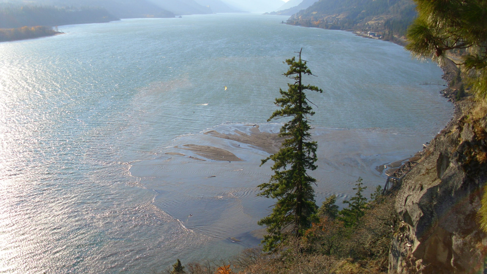
The first launch Nov, 2011
 |
| |
eyrie 066.JPG |
_________________
moondog |
|
|
moondog
Since 15 Aug 2007
698 Posts
white salmon
Addicted
CGKA Member
|
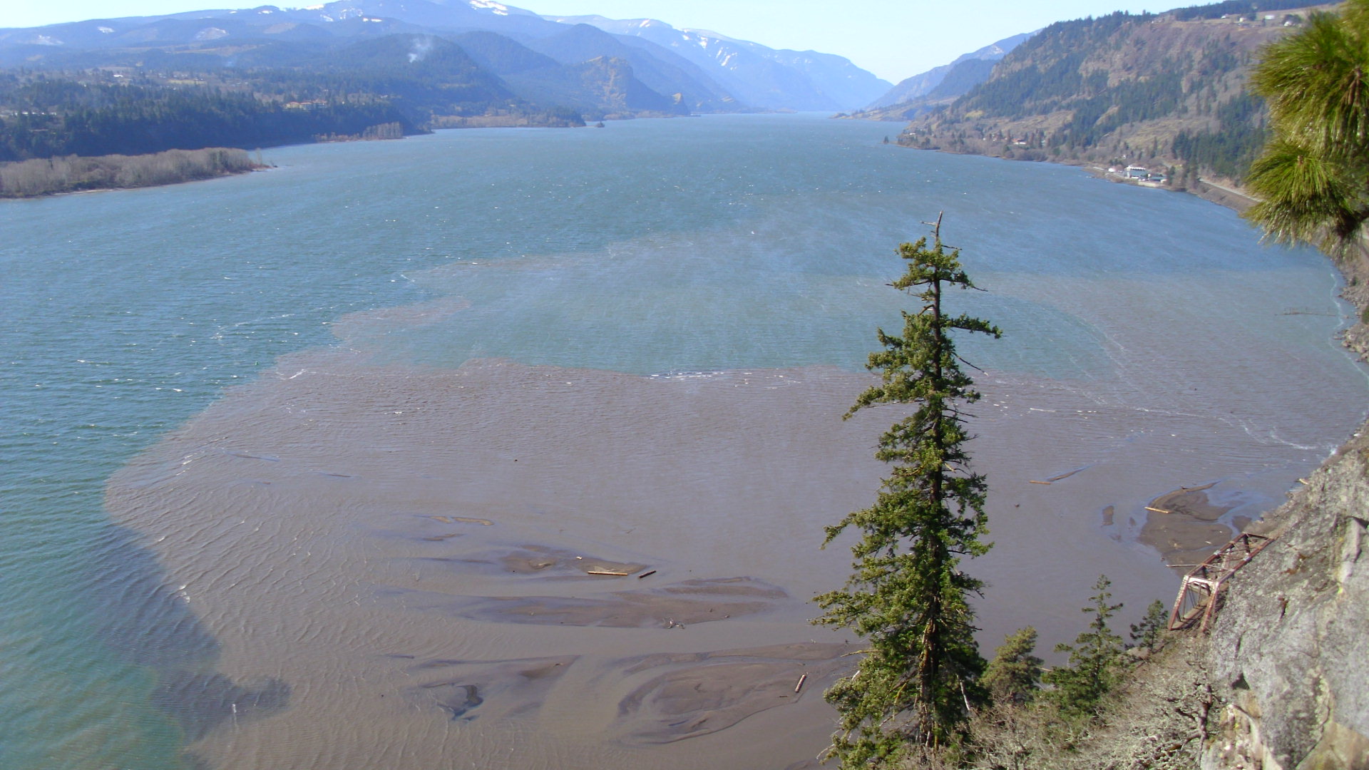
| Wed Mar 07, 12 5:56 pm march 7, 2012 update photo |
|
|
After the heavy winter rain and snow season I was disappointed not to see a more pronounced sandbar. It has grown in size but not much is above water. The water level was low today. The HR sandbar was out in it's full glory. Most of the WS bar was 2-6 inches below water, but huge! The waves were very small just upwind of the bar. To the south of it we had the typical 2-3 foot swell. Somehow we need the mass of sand at the Native American in lieu site to build up the existing base.
 |
| |
Mexico 2012 226.JPG |
 |
| |
Mexico 2012 230.JPG |
_________________
moondog |
|
|
hilton
Since 15 Aug 2008
787 Posts
Opinionated
|
| Wed Mar 07, 12 6:05 pm |
|
|
I walked around a bit on the new sand bar Sunday.
Much like the HR bar, the outside edge is soft and drops off fast.
The middle, however, felt quite solid although it was (as you said) under water between calf and thigh deep.
The water upwind of the new sandbar was (sadly) pretty flat.
Much flatter than the waves/swell out in the main channel.
|
|
|
genek

Since 21 Jul 2006
2165 Posts
East Po
KGB
|
| Thu Mar 08, 12 4:34 pm |
|
|
| hilton wrote: | I walked around a bit on the new sand bar Sunday.
Much like the HR bar, the outside edge is soft and drops off fast.
The middle, however, felt quite solid although it was (as you said) under water between calf and thigh deep.
The water upwind of the new sandbar was (sadly) pretty flat.
Much flatter than the waves/swell out in the main channel. |
Booya! New kiddie pool with fewer kooks and cleaner wind?
_________________
The Slider Project, LLC
Support the cause!
http://www.sliderproject.com/ |
|
|
dangler

Since 26 Feb 2006
1744 Posts
WINDY SPOTS
XTreme Poster
|
| Thu Mar 08, 12 4:52 pm Save toll |
|
|
It would be nice to avoid the bridge toll from carson
_________________
Kite Repair? AND LABRADORS Call me.(509) six 37-four five 29 |
|
|
apctjb
Since 19 Aug 2007
427 Posts
Obsessed
|
| Fri Mar 09, 12 4:10 pm |
|
|
Anyone know if there are plans to dredge a channel to the Indian boat ramp?
That could add some extra spoils to the bar...
|
|
|
apctjb
Since 19 Aug 2007
427 Posts
Obsessed
|
| Fri Mar 09, 12 4:15 pm |
|
|
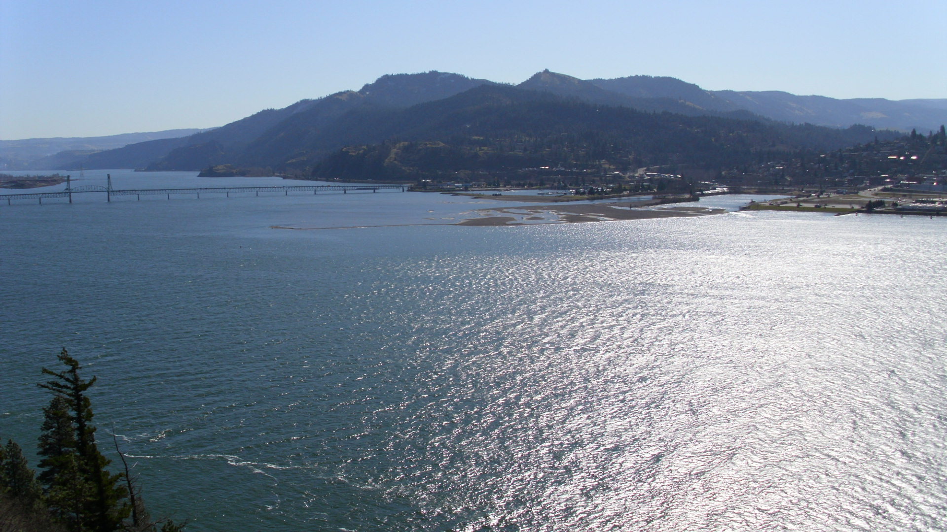
Sand bar as of today; if you look in the middle you can see someone out trying out the new "pool"
 |
| |
White Salmon sandbar.jpg |
|
|
|
kitezilla
Since 22 Jun 2006
453 Posts
gorge
Obsessed
|
| Thu May 17, 12 12:03 pm |
|
|
Wanted: "Sleuths" and "Observers"
This should be an interesting 5 month period, concerning 2 related 'natural' phenomenum...swell on the river, and sand bar transformation.
If you look at the old picture of the WS delta, taken from the Eirie, you may find a few hints of what is to come. My guess is that the picture was taken on a day in August, based on the fact that the river is low (judged from the distance the water is from the shrubs on the shore). I would guess August because of the windless appearance of the river, the leaves on the Oak tree, and the high position of the sun. My guess is that the sand bar will look like that in the picture, this August.
Can you find any other things in the picture, that would be fun, on which to base a hypothesis?
As far as "swell" (technically, or more accurately, 'chop') goes... the subject gets very interesting... where will it be best, when, and under what flow conditions of the Columbia and WS rivers?
In guessing at the "swell", here are two basic facts to be considered:
(1) Ocean or lake waves: The waves move, but the individual molecules of the water stay in one place (going in little circles).
(2) River or Ocean current waves: The waves stay in one place, but the individual molecules of the water move (all the way from its source to its destination) .
A third fact to be considered where water is driven by 'current', is that: When fast water meets slow water, a hump, (standing wave, like you see on a river) will occur.
A forth thing that will cause a hump or water to form, is where a wave 'feels' the bottom, as it encounters a shallow area.
When you put together these 4 phenomenon, you may be able to form a hypothesis, explaining the 'what, where and when' of swell formation on the Columbia River.
Put on your thinking caps and clean your sun glasses...
|
|
|
mazzi
Since 28 Jul 2008
6 Posts
Portland, OR
Kook
|
| Thu May 17, 12 1:42 pm |
|
|
It will be interesting to see what happens to the bar over the next several seasons. I have a personal and professional interest in river dynamics and it has been fun to read everybodys different hypothesis. The physical processes involved in the evolution of the sandbar are extremely complex and not fully understood by science (at every scale). There are advanced morphological models that can account for the first order processes but its difficult to accurately define all the inputs, account for natural variability (i.e. sediment supply), and collect data to calibrate and validate such a model. Bottom line
anybody who tells you that they KNOW whats going to happen to the sand bar is a fool. The best indicator as to whats going to happen is to look at other tributaries, as some folks have pointed out.
The more relevant question for kiters (as kitezilla has pointed out) is: what impact will the new sandbar have on the water conditions, mainly swell.
Kitezilla - I like your attempt to identify the first order controlling processes but, no offense, they arent relevant (nor are they all accurate). Youre missing the driving force, WIND. If swell were only controlled by bathymetry (the river bottom) and current speed, the waves would be there with, or without, wind which they are not. WIND is the primary driving force.
Then question becomes: why are the waves bigger in certain areas (i.e. pre-dam breach White Salmon, Arlington, Dougs Beach, Hatch, etc.)? What do all those areas have in common? Higher current speed (velocity) thats the second requirement for big swell. Each of the sites have higher velocities for different reasons; most are from a slight channel constriction, and you can see that in Google Earth. The Hatch is a natural bedrock outcrop that causes localized flow acceleration, Dougs in the same, the areas just east of wind mt. is another natural constriction which has massive swell. Arligntons big swell is caused by the manmade marina which creates localized swell just downstream near the OR side you all know where it is. The story at White Salmon is less obvious and cant be seen from Google Earth. The flow acceleration there was being caused by the old underwater delta which was there before the dam came out, as somebody pointed out. River currents would accelerate over the top of that underwater delta creating higher velocities, more wind drag, and thus bigger swell. So the question about what will happen to the swell with the new sandbar depends on what the new river bathymetry looks like and what affect that will have on local velocities. It seems like the sediment wedge is now causing flow to go around, rather than over, the delta which will still create flow acceleration and swell conditions. From early observations (kiting) there is still swell downstream of the mouth but the waves seem more unsettled (but Ive only been out twice this year). I wonder if thats related to there being more turbulence. The flow transition is more dramatic than it used to be and maybe thats creating a lot more turbulence. In any event, expect the sandbar geometry and swell characteristics continue to change as the river slowly adjusts to its new dynamic equilibrium. It will probably take several seasons for the changes to slow down, depending on how well they control the remaining upstream sediment.
Sorry for all the nerd talk, somebody else started it
|
|
|
mazzi
Since 28 Jul 2008
6 Posts
Portland, OR
Kook
|
| Thu May 17, 12 1:43 pm |
|
|
It will be interesting to see what happens to the bar over the next several seasons. I have a personal and professional interest in river dynamics and it has been fun to read everybodys different hypothesis. The physical processes involved in the evolution of the sandbar are extremely complex and not fully understood by science (at every scale). There are advanced morphological models that can account for the first order processes but its difficult to accurately define all the inputs, account for natural variability (i.e. sediment supply), and collect data to calibrate and validate such a model. Bottom line
anybody who tells you that they KNOW whats going to happen to the sand bar is a fool. The best indicator as to whats going to happen is to look at other tributaries, as some folks have pointed out.
The more relevant question for kiters (as kitezilla has pointed out) is: what impact will the new sandbar have on the water conditions, mainly swell.
Kitezilla - I like your attempt to identify the first order controlling processes but, no offense, they arent relevant (nor are they all accurate). Youre missing the driving force, WIND. If swell were only controlled by bathymetry (the river bottom) and current speed, the waves would be there with, or without, wind which they are not. WIND is the primary driving force.
Then question becomes: why are the waves bigger in certain areas (i.e. pre-dam breach White Salmon, Arlington, Dougs Beach, Hatch, etc.)? What do all those areas have in common? Higher current speed (velocity) thats the second requirement for big swell. Each of the sites have higher velocities for different reasons; most are from a slight channel constriction, and you can see that in Google Earth. The Hatch is a natural bedrock outcrop that causes localized flow acceleration, Dougs in the same, the areas just east of wind mt. is another natural constriction which has massive swell. Arligntons big swell is caused by the manmade marina which creates localized swell just downstream near the OR side you all know where it is. The story at White Salmon is less obvious and cant be seen from Google Earth. The flow acceleration there was being caused by the old underwater delta which was there before the dam came out, as somebody pointed out. River currents would accelerate over the top of that underwater delta creating higher velocities, more wind drag, and thus bigger swell. So the question about what will happen to the swell with the new sandbar depends on what the new river bathymetry looks like and what affect that will have on local velocities. It seems like the sediment wedge is now causing flow to go around, rather than over, the delta which will still create flow acceleration and swell conditions. From early observations (kiting) there is still swell downstream of the mouth but the waves seem more unsettled (but Ive only been out twice this year). I wonder if thats related to there being more turbulence. The flow transition is more dramatic than it used to be and maybe thats creating a lot more turbulence. In any event, expect the sandbar geometry and swell characteristics continue to change as the river slowly adjusts to its new dynamic equilibrium. It will probably take several seasons for the changes to slow down, depending on how well they control the remaining upstream sediment.
Sorry for all the nerd talk, somebody else started it
|
|
|
blireef
Since 31 Aug 2009
37 Posts
|
| Thu May 17, 12 3:00 pm |
|
|
I'm looking at all the cams available and am not seeing the sandbar, does anyone have a current image of it, is it still above water?? Big Jim 
_________________
bigjim |
|
|
moondog
Since 15 Aug 2007
698 Posts
white salmon
Addicted
CGKA Member
|
| Fri May 18, 12 8:05 am where am it? |
|
|
When the HR sandbar has a small crescent showing, the WS bar is under water. I went out tuesday and it was completely submerged with just a couple of ankle breaking logs visible, one upstream and one downstream. I went within 50 yards of the bridge where I knew it was shallow and slowly dismounted from my board and started sinking up to my knees. It will take a full season for everything to stabilize. When the HR bar is in it's full glory the WS bar has about 200 square yds. of useable space with lots of debris to catch kites and lines. The wave dynamics are totally different this year with pros and cons depending on your kiting preferences.
_________________
moondog |
|
|
Ryan
Since 14 Jul 2005
536 Posts
Oregon
Addicted
|
| Fri May 18, 12 9:32 am waves |
|
|
Mazzi, I agree with you. Lets not forget fetch. All those locations have a long strait upwind river section to build waves. Also, to much velocity is not good either, ie Rufus most of last summer.
I just hope we launch and land from the WS SB and the head upwind to the waves.
|
|
|
kitezilla
Since 22 Jun 2006
453 Posts
gorge
Obsessed
|
| Fri May 18, 12 11:50 am |
|
|
Here are 3 other factors that I think will become important in the discussion of the "what, where and when" of these 'humps' of water, on which, we love to play.
(1) The density of water being over 700 times that of air. The relevance of this will be more obvious, if you consider the force and inertia, exerted by wind (moving air) of 10 MPH compared to the force and inertia of a stream of water, moving 10MPH.
(2) "Wave Trains" ... those formed on a river, by moving water, as a result of a 'drop and pool' feature... compared to the wave trains formed on a lake or ocean, as a result of the pressure of moving air. The waves formed in a classical wave train resulting from a 'drop' in the river, stay in pretty much the exact same spots... whereas the individual waves in a 'set' of waves, resulting from wind, will rotate, where the leader wave will disappear, and reform at the tailend of the wave train. The Columbia River combines both of these wave train phenomenon to create the humps of water that we so love.
(3) The casual use of the words "wave" and "swell" as opposed to the technically accurate use of the words, along with the word "chop". People who live or surf on the ocean have always been annoyed at the misuse of these words, by Gorge people, and I have to agree with them... but I also have to agree with them, when they admit that whatever you call the 'humps of water', that are found in the Columbia River Gorge...that those humps are a lot of fun.
We have all noticed that "too much" current and "too little" river current, wreck the "swell", by either shortening up the 'wave period' too much... or flatening out the height of the 'wave'. The above listed factors (1) and (2) may be helpful in figuring out the "why" of this observation.
Wheeew! Deep stuff!
For the "Geek-challenged" Dudes, who, about now, would like to give me and my "Dude-challenged" Bros, participating in this discussion... a virtual Atomic Wedgie, here is what we are talking about:
" If you feel like your teeth are gonna break, it's chop. If you feel like your back is gonna break, it's a swell."
|
|
|
Sella

Since 21 Apr 2007
1794 Posts
Doin' The Dalles
FLY'IN HIGH PIE GUY
|
| Fri May 18, 12 12:38 pm |
|
|
| kitezilla wrote: | | Wheeew! Deep stuff! For the "Geek-challenged" Dudes, who, about now, would like to give me and my "Dude-challenged" Bros, participating in this discussion... a virtual Atomic Wedgie, |
If you're going to get technical...I wouldn't say it's an Atomic Wedgie. It's no small tug on the taint. It's more like a wide ass gaping.
You can play in the northern shoreline butter while scanning the roller coaster of fun from the green buoy up past wells and see a corridor of swell. Some choppy....some clean....some just ridiculous.....but every time you cross the river it's like punching another free ticket to ride it.
It's Friday.....go get your fill. 
|
|
|
|
|
You cannot post new topics in this forum
You cannot reply to topics in this forum
You cannot edit your posts in this forum
You cannot delete your posts in this forum
You cannot vote in polls in this forum
You can attach files in this forum
You can download files in this forum
|
|

