|
previous topic :: next topic |
| Author |
Message |
undertow

Since 15 Feb 2008
371 Posts
BeaversBurg
Obsessed
|
|
|
moondog
Since 15 Aug 2007
698 Posts
white salmon
Addicted
CGKA Member
|
 Sat Nov 26, 11 5:13 pm Sat Nov 26, 11 5:13 pm |
 |
|
I went down Sat. to the mouth and was totally amazed what has happened since Tues. The east side of the river has a sandbar extending out 100 yards or so. The indian access is toast, completely sandbared in. The WS river has found a major channel on the east side of the pool. When the columbia rises in the spring we will have many new surprises by July.
_________________
moondog |
|
|
apctjb
Since 19 Aug 2007
427 Posts
Obsessed
|
| Sat Nov 26, 11 7:11 pm |
|
|
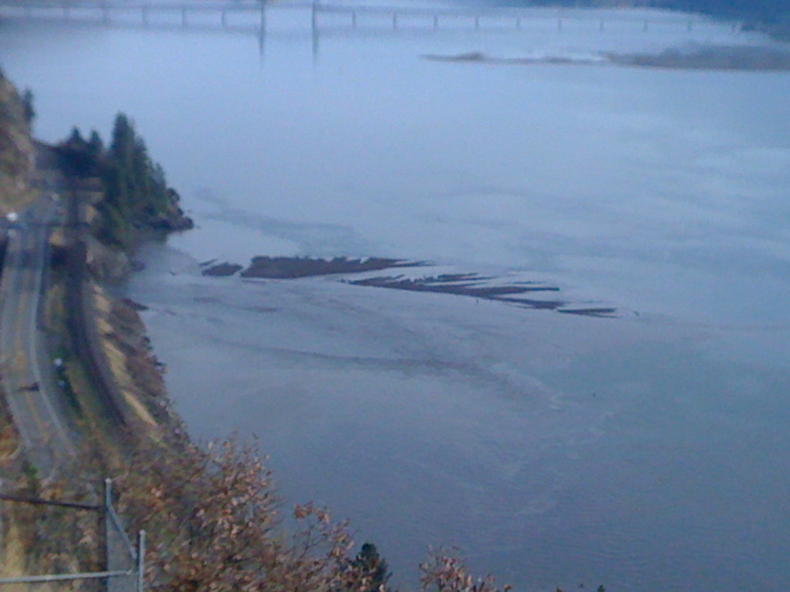
Photo of sand bar from the bluff
 |
| |
WS sandbar.jpg |
|
|
|
moondog
Since 15 Aug 2007
698 Posts
white salmon
Addicted
CGKA Member
|
| Sun Nov 27, 11 8:45 am |
|
|
nice shot! we will use it as a baseline photo for the next year comparing the breathe of the WS sandbar from week to week.
_________________
moondog |
|
|
moondog
Since 15 Aug 2007
698 Posts
white salmon
Addicted
CGKA Member
|
| Sun Nov 27, 11 8:49 am |
|
|
I just noticed it's mother in the background, I hope it grows up to look like it's mommy!
_________________
moondog |
|
|
apctjb
Since 19 Aug 2007
427 Posts
Obsessed
|
| Sun Nov 27, 11 9:42 am |
|
|
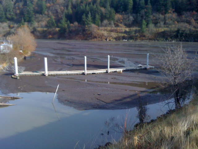
Here is a shot of the fishing access site near the mouth. Any one know if there are plans to dredge this to reinstate access or is it going to be abandoned?
If dredging is planned then there is alot more material that could be added to a sand bar...
 |
| |
WS.JPG |
|
|
|
hoarhey

Since 20 Jul 2008
63 Posts
the corridor
|
| Sun Nov 27, 11 2:04 pm |
|
|
The natives accepted a .5 million dollar payment to leave the site "as is". Obviously nature will make it reusable at some distant point in the future. Bottom line; more sediment to be added to the equation.
_________________
Misinformed |
|
|
captain crusty

Since 30 Aug 2005
92 Posts
PDX
|
| Mon Nov 28, 11 8:35 am |
|
|
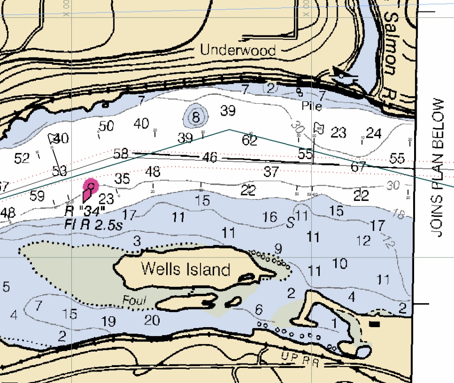
the chart before
deepest part of the river is not along the bank. dotted lines is the nav channel
there is a submerged sediment fan about 23 ft deep there
and the sed is building on that, if the new sandbar impedes on the nav channel they will dredge it to keep the barges movin
 |
| |
ws chart.jpg |
|
|
|
pdxmonkeyboy

Since 16 May 2006
6081 Posts
forever labled as the
retired kiter & motorhead Unicorn Master
|
| Mon Nov 28, 11 11:12 am |
|
|
| hoarhey wrote: | | The natives accepted a .5 million dollar payment to leave the site "as is". Obviously nature will make it reusable at some distant point in the future. Bottom line; more sediment to be added to the equation. |
ummm, the understanding around the office is that they were paid .5 million to cover dredging expenses, NOT to leave it alone. They would never just abandon a fishing site.
_________________
Bury me standing cause I won't lay down!!
http://www.youtube.com/watch?v=BVvAw2VFR4Y&feature=PlayList&p=FB7233C37686AC79&playnext_from=PL&playnext=1&index=34 |
|
|
kitezilla

Since 22 Jun 2006
453 Posts
gorge
Obsessed
|
| Mon Nov 28, 11 2:00 pm |
|
|
The subject of "dredging" raises some interesting questions. For instance, could they take some excavators and dig up the silt and sand and gravel and rocks and just dump it into the flow of the WS river?... whereby it would allow the 'spoils' to add to the growing delta. Or would this be prohibited, and would the spoils have to be trucked away... maybe to be used as fill for construction projects... or possibly the dredged material would be graded and sold as sand and gravel. Below is a section, taken from Wikipedia discussing the grading of aggregate:
"Sand feels gritty when rubbed between the fingers (silt, by comparison, feels like flour).
ISO 14688 grades sands as fine, medium and coarse with ranges 0.063 mm to 0.2 mm to 0.63 mm to 2.0 mm. In the United States, sand is commonly divided into five sub-categories based on size: very fine sand (1⁄16 ⅛ mm diameter), fine sand (⅛ mm ¼ mm), medium sand (¼ mm ½ mm), coarse sand (½ mm 1 mm), and very coarse sand (1 mm 2 mm). "
I wonder what all that 'muck, in the picture consists of? The stuff may have enough value, that a sand and gravel business could be set up in the old pond... and a lot of the 'burden' of material getting washed down the WS river could be intercepted, carted away, and sold for profit, before it has a chance to add itself to the growing delta.
|
|
|
pdxmonkeyboy
Since 16 May 2006
6081 Posts
forever labled as the
retired kiter & motorhead Unicorn Master
|
|
|
apctjb
Since 19 Aug 2007
427 Posts
Obsessed
|
| Mon Nov 28, 11 7:43 pm |
|
|
Beer? What happened to the offer of cold hard cash...
| Quote: | pdxmonkeyboy
Since 16 May 2006
5876 Posts
forever labled as the
Unicorn Master
Mon Sep 01, 08 6:48 pm
--------------------------------------------------------------------------------
jblum wrote:
I partly agree, but mostly disagree here.
We could put $20 on it if you want. The white salmon empties into the columbia on the outside bend of the channel meander. This is the deepest and fastest flowing part of the river. Suspended sediment load means nothing if the sediment does not have a place to settle out of suspension. If you look at aerial photos of the cpulmbia you'll see what i'm talking about. There is either a natural land mass that causes a backwater (Lyle) or sand bars are on the inside bend of channel meanders..HR.
If anything, you can look to see wells island grow a little bit but I'll put cold hard cash down that the damn removal will not form a sand bar at the mouth.
|
|
|
|
moondog
Since 15 Aug 2007
698 Posts
white salmon
Addicted
CGKA Member
|
| Tue Nov 29, 11 9:31 am |
|
|
This is a question for all you hydrologists out there. Kayaking out here last week the eddy on east side of the mouth only extended out 20 yards until the columbia flow kicked in and turned the flow west. Why is this new bar extending out 200 yds. on the east side or up river side? All the other bars on the columbia are on the west or downriver side. This WS bar makes no sense!
_________________
moondog |
|
|
Mark

Since 20 Jun 2005
3677 Posts
I need my fix because I'm a
Naishaholic
|
| Tue Nov 29, 11 10:38 am |
|
|
Can see sandbar on right!
 |
| |
WSandbar.jpg |
_________________
Cleverly disguised as an adult...
www.naishkites.com |
|
|
kitezilla
Since 22 Jun 2006
453 Posts
gorge
Obsessed
|
| Tue Nov 29, 11 1:41 pm |
|
|
Moondog,
You are going to be sorry you asked, but here goes:
I'm no hydrologist, but I have spent a lot of time in the water
From my research, I would guess that we are dealing with a "Fluvially Dominated Delta", which is being formed by 2 main forces generated by the WS river, and a 'tidal-like' force being generated by the Columbia River. Below are the descriptions of the two WS river forces and two diagrams illustrating the forces.
I would guess that the Columbia River, with its fluctuating river level rise and fall, due to the regulation by The Dalles and Bonneville dams, along with its fluctuation in current speed
does a pretty good imitation of action of the tides and littoral current, as in a situation where a river dumps into the ocean. The wind and wave direction fluctuate also, but since East wind tends to skip the Corridor, the West wind and west wave action predominates.
If you put all that together, you can come up with a hypothesis explaining the apparently abnormal deposition of the aggregate, to the Columbia's upstream side of the WS river delta.
I would guess that both surface water flows, eddies, and waves, along with sub-surface flows, and actions due to underwater "rotor waves", coriolus corkscrews, 'vertical eddies', and other types of turbulence would contribute to the overall deposition forming the sand bar.
The main thing to consider is that silt falls out of the water flow when something slows down the water current.
So, here is a hypothesis explaining why the only sand bar we see forming, SO FAR, is located the the East of the mouth of the WS river:
As the WS water flows into the Columbia, it fans out to both the east and west side of the channel. The flow that goes to the East, hits the main flow of the Columbia at an angle and this SLOWS the flow, and allows the 'burden' of silt to sink and build up a sand bar. The WS water that fans out to the West is accelerated by joining the current of the Columbia, and therefore stays in suspension, and is swept down stream, and does not form a ridge of sandbar, to the west of the WS mouth
To this hypothesis, you could add the effect of "standing waves", where the fast water meets the slow water, and a whole lot more, like the westerly wave action fighting the current of the Columbia and acting to pile up sand, originally deposited in the center of 'lunate bar', onto the east sand bar.
Friction-dominated deltas are associated with high bed friction and shear stress. These stresses cause the flow to slow down rapidly and deposit sediment with a wider lateral extent than the inertia-dominated deltas. The river/basin setting for this type of situation is more common. It consists of a shallow water level where the river flow and basin meet. This shallow area is a major factor in producing a friction-dominated delta. Features associated with this type of delta include subaqueous levees, middle ground bars (fining seaward), and bifurcated channels.
Inertia-dominated deltas are considered to be an uncommon dominance for deltas. They are associated with high flow velocities and large amounts of turbulence. As shown in the figure above, sediments are deposited close to the main flow of the channel as it enters the basin. In other words, the deposition of sediments in inertia dominated deltas does not have a large lateral component.
..
| Description: |
|

Download |
| Filename: |
Inertia-dominated deltas.jpg |
| Filesize: |
540.72 KB |
| Downloaded: |
575 Time(s) |
| Note: |
Use Pixlr to resize images to lower than 1024x768 resolution so they show up inline. |
| Description: |
|
Download |
| Filename: |
friction dominated delt.jpg |
| Filesize: |
633.04 KB |
| Downloaded: |
580 Time(s) |
| Note: |
Use Pixlr to resize images to lower than 1024x768 resolution so they show up inline. |
|
|
|
kitezilla
Since 22 Jun 2006
453 Posts
gorge
Obsessed
|
| Tue Nov 29, 11 2:13 pm |
|
|
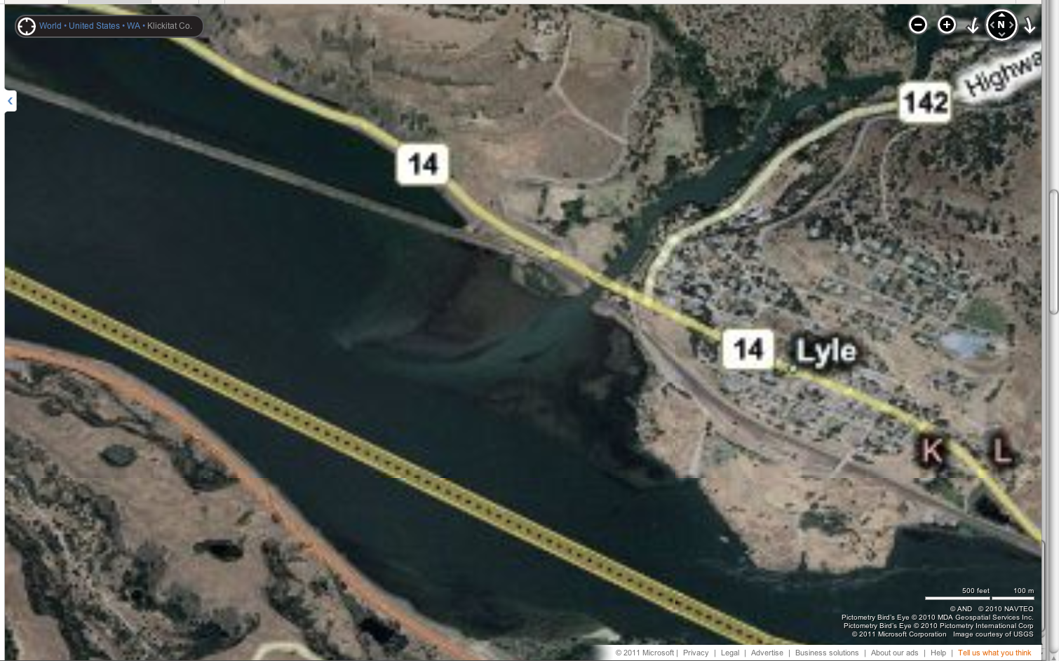
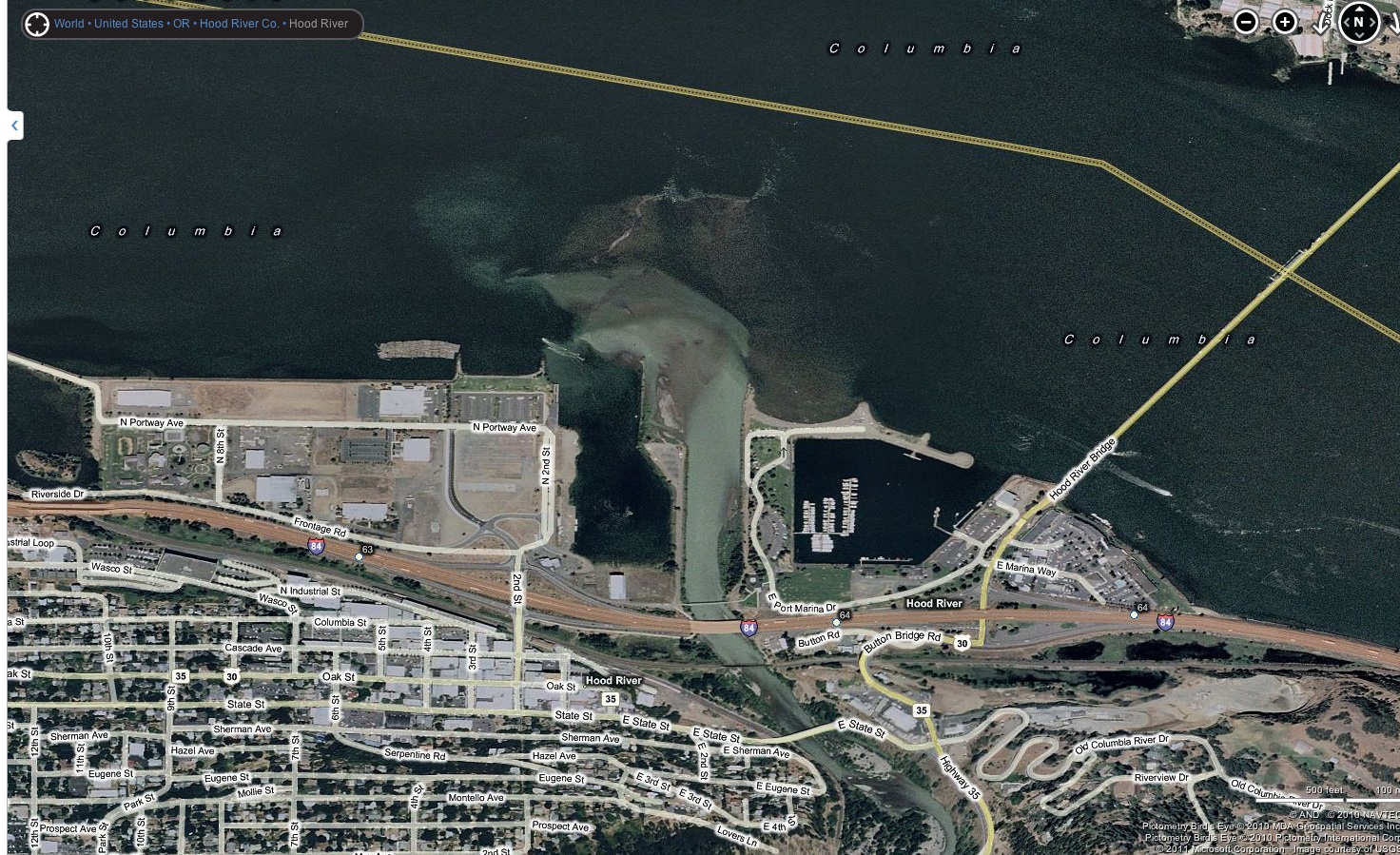
| moondog wrote: | | Why is this new bar extending out 200 yds. on the east side or up river side? All the other bars on the columbia are on the west or downriver side. This WS bar makes no sense! |
Here are 2 pictures from BING, showing the types of sand bars that have built up on the upstream side of the river mouths of the Hood River and the Klick:
 |
| |
Klick upstream bar.png |
 |
| |
HR upstream bar.jpg |
|
|
|
moondog
Since 15 Aug 2007
698 Posts
white salmon
Addicted
CGKA Member
|
| Tue Nov 29, 11 9:11 pm |
|
|
Thanks Senor Kitezilla, That was a heavy dissertation that I will try to study for the next year or so. The big difference is the Lyle sandbar has a huge landmass up river protecting the sand bar which is downriver and the bulk of the HR sandbar is downriver.
_________________
moondog |
|
|
|