|
previous topic :: next topic |
| Author |
Message |
pdxmonkeyboy

Since 16 May 2006
6081 Posts
forever labled as the
retired kiter & motorhead Unicorn Master
|
 Tue Nov 15, 11 8:28 am Tue Nov 15, 11 8:28 am |
 |
|
kiw winger... sounds like we need to bet a 6-pack of beer on the presence or absence of a sand bar there come next summer. 
Its anyone's guess but again, the deepest part of the channel runs along the bridge and we are in the lowest flows for the river right now. A bunch of rain, higher flows, and the WAVE ACTION on that bar will definitely eat away at it. There may be a sliver left, but it certainly won't look like it does now. Think about how much the wind and waves eats away all the gravel at the steven launch.
Love that historic picture. It would definately look like that now...if all the sediment wasn't locked up behind the 7? dams on the mainstem columbia upstream. What I like to think about is that if you look at the sheer volume of sediment that was behind the condit dam, just think about how much is pilled up behind bonneville dam!
The pool/pond to the north represents a different problem all together. I'm not sure what they are going to do to deepen the channel in that area. The issue is that the steeper sections up stream are confined by the bedrock valley walls which cause high velocity which transports all that sediment downstream.
When the river hits the much wider and slower portion by the pond, all that sediment settles out. While the constriction of the bridge will initiate a scour pool just downstream, not sure if that scour will translate much farther upstream and create a deeper channel through the mud. In theory, you could install some log jams and concentrate the flow trough the pond and thus scour a channel. The problem is that in high sediment deposition areas, many times the stream will meander around the log jams.
Fascinating stuff for sure. I can't wait until we start getting buckets of rain!
_________________
Bury me standing cause I won't lay down!!
http://www.youtube.com/watch?v=BVvAw2VFR4Y&feature=PlayList&p=FB7233C37686AC79&playnext_from=PL&playnext=1&index=34 |
|
|
kitezilla

Since 22 Jun 2006
453 Posts
gorge
Obsessed
|
| Tue Nov 15, 11 9:14 am |
|
|
Of course, the "hand of man" and the "invisible hand of the free market system" could give some 'dope or bitch slaps' to Mother Nature. For instance, what would keep the Indian owners from stabilizing the "mud" in the 'Pool', gaining a little real estate, maybe putting up some bulkheads, forcing the WS river channel to the East...and then, "pave paradise to put up a parking lot"...and a nice little marina.
I wonder what the hydrologist consultants are betting on?
|
|
|
pdxmonkeyboy
Since 16 May 2006
6081 Posts
forever labled as the
retired kiter & motorhead Unicorn Master
|
|
|
pkh

Since 27 Feb 2005
6549 Posts
Couve / Hood
Honored Founder
|
| Tue Nov 15, 11 3:53 pm |
|
|
| That's always been my reasoning... everywhere in the Gorge that there is a river coming into the Columbia, you get a sandbar.
|
|
|
jdk
Since 21 Dec 2005
333 Posts
Obsessed
|
| Tue Nov 15, 11 4:11 pm |
|
|
| having any kind of sandbar adjacent to the channel would be so fun. there's a similar setup across from the corbett exit (works on east days). could be all time
|
|
|
moondog
Since 15 Aug 2007
706 Posts
white salmon
Addicted
CGKA Member
|
| Tue Nov 15, 11 4:12 pm |
|
|
Did my final kayak trip up the mouth of the WS river today. The bar has extended out 50 more feet into the Columbia from last week. It is now forming on the east side also because of the strong east eddy. kayaked down 1/4 mile west to the old dock pilings and found very little sediment there. I'm going to bet 5 euros that we will have small sandbar on both sides of the bridge next summer. We will have an inch of rain the next 3 days, so that will help tell the tale.
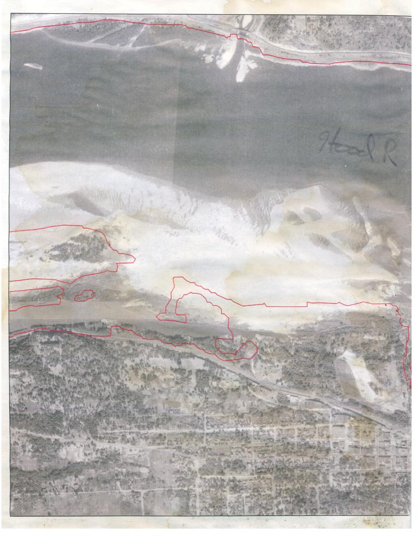
The fishermen mood has been upgraded from irate to livid!!! The WS pool to the N is looking shallower and shallower, used to be 20ft. now inches. The 1931 photo below might be what we see after the columbia is lowered in the summer. Doesn't really do us much good since we have no access with RR issues!
 |
| |
Sandbar1.jpg |
_________________
moondog |
|
|
kitezilla
Since 22 Jun 2006
453 Posts
gorge
Obsessed
|
| Tue Nov 15, 11 4:34 pm |
|
|
| Access: walk under the RR trestle to the sand bar?
|
|
|
moondog
Since 15 Aug 2007
706 Posts
white salmon
Addicted
CGKA Member
|
| Tue Nov 15, 11 5:54 pm |
|
|
There are some salmon-slayers there that feel this is their territory. I've already dealt with them in earlier years below the Bonneville Dam. It got fairly ugly. It's like turf wars in LA! I personally don't think the sandbar will be big enough to stretch 10 kites with 25 meter lines.... but if it is huge it won't be an issue. Let's hope!
_________________
moondog |
|
|
Sauve
Since 19 Mar 2009
97 Posts
Hood River
|
| Tue Nov 15, 11 7:57 pm |
|
|
i think mother nature has been our best friend since the forging of the gorge to the thermal setup to the flood that brought our hood river sandbar... no doubt we keep harnessin' that wind power, and OL MOTHA earth will keep buildin our playground.
im keepin my fingers crossed for over head BREAKING waves at the bridge next spring
_________________
Sean Sauve |
|
|
forrest

Since 21 Jun 2005
4330 Posts
Hood River
Hick
CGKA Member
|
| Tue Nov 15, 11 9:17 pm |
|
|
| If there is a chance for access you know the CGKA will be all over trying to preserve it.
|
|
|
Sella

Since 21 Apr 2007
1794 Posts
Doin' The Dalles
FLY'IN HIGH PIE GUY
|
| Tue Nov 15, 11 9:58 pm |
|
|
A summer of kiting from this spot seems just incredible but Monkey's forecast is valid.
| pdxmonkeyboy wrote: | | Its anyone's guess but again, the deepest part of the channel runs along the bridge and we are in the lowest flows for the river right now. A bunch of rain, higher flows, and the WAVE ACTION on that bar will definitely eat away at it. There may be a sliver left, but it certainly won't look like it does now. Think about how much the wind and waves eats away all the gravel at the steven launch. |
Screw any "pray for wind" Spring parties......let's "pray for WSliver bar".
|
|
|
Ryan
Since 14 Jul 2005
540 Posts
Oregon
Addicted
|
| Tue Nov 15, 11 10:46 pm Time will tell |
|
|
I went to a panel discussion this evening where the manager for the Condit dam removal for Pacific Corps was there. I spoke to him about the sediment deposition at the mouth. All their analysis shows almost zero net deposit at the mouth. sure there may be some small deposits along the edges but nothing significant. They are looking at a 10 year time frame which is the length of their permit. so over the course of the next couple years as the sediment moves down the river there could be something there.
I dont thing there is any chance the system will look anything like the Klickitat bar. the mouth of the Klickitat is well protected from the Columbia and the WS mouth is not.
Time will Tell
|
|
|
kitezilla
Since 22 Jun 2006
453 Posts
gorge
Obsessed
|
| Wed Nov 16, 11 7:22 am |
|
|
As if we don't have enough to worry about:
(1) Loss of access from OUR new kite beach at the mouth of the WS river... from someone lofting a kite into the path of a speeding freight train, inflated kites being carried across hwy 14, kiters being dragged into fishing nets.
(2) Windsurfers, picnickers, fishermen, whitewater kayakers and jet skiers camping out on our new beach, and getting in the way of our kites and lines.
(3) Burlington Northern railroad "bulls" ticketing us for taking a shortcut over the tracks to our new beach.
Here's what I my research just turned up:
Lewis and Clark passed the Sandy River on November 3, 1805, and called the river "Quicksand River", after finding the mouth shallow and impassable. Here is what they said in their journal:
"... at 3 miles I arrived at the enterance of a river which appeared to Scatter over a Sand bar, the bottom of which I could See quite across and did not appear to be 4 Inches deep in any part; I attempted to wade this Stream and to my astonishment found the bottom a quick Sand, and impassible -- ..."
It turns out that a year or so, before Lewis and Clark got there, Mt Hood sent a big bolus of silt down the Sandy River, forming a new sandbar delta...Sound familiar?
Now, we gotta worry about QUICKSAND!
|
|
|
moondog
Since 15 Aug 2007
706 Posts
white salmon
Addicted
CGKA Member
|
| Wed Nov 16, 11 8:50 am |
|
|
Ryan, did the native american in lieu site come up in the discussion? It is now unusable because of the sediment surrounding it. I smell a lawsuit and a dredging project coming soon . I agree with your Klickitat analysis since it is away from the main channel. Kitezilla's reference to Lewis and Clark and quicksand is happening right now. Checking the water depth yesterday, my paddle would get sucked down over a foot in the unstable sediment.
_________________
moondog |
|
|
Pepi

Since 16 Jun 2006
1832 Posts
Pure Stoke Sports
Shop Owner
CGKA Member
|
| Wed Nov 16, 11 9:37 am |
|
|
Just to make sure to throw it out there, at this moment, as far as I am aware and especially since the accidental death on the tracks at this specific location 3 yrs ago, crossing of any railroad tracks is illegal and thus the reason for the 1/2 mile long cyclone fence all along this section of railroad tracks.
Just something to think about for anyone claiming this as a new public access location.
This the exact same scenario as Lyle, except it is much more publicly visible and policed, and has an existing user base that have a staked claim in (non-legal) access.
Kiting up to this location from the HR Sandbar is still likely the continuing scenario.
The CGKA has had some discussions about this, but it's going to be a pretty touchy subject and doesn't allow for much opportunity.
_________________
Pure Stoke Sports
Hood River, OR
http://www.facebook.com/pages/Hood-River-OR/2nd-Wind-Sports/35891485558?ref=mf
www.Purestokesports.com |
|
|
4Stringer/KipWinger

Since 27 Apr 2005
541 Posts
Hood River
Addicted
|
| Thu Nov 24, 11 12:05 pm Thanksgiving update |
|
|
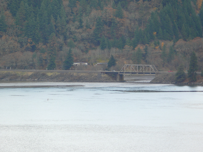
The water in the Columbia is not particularly low today and there's a long thin patch of sand visible to the naked eye (from Hood River) at the mouth of the White Salmon today. I'd suggest at your Thanksgiving meal that you give thanks for the White Salmon snatch patch.
Here's one from Thanksgiving day;
 |
| |
ws bar.jpg |
_________________
revitalized by muthu-nachu |
|
|
hoarhey

Since 20 Jul 2008
63 Posts
the corridor
|
| Sat Nov 26, 11 12:08 pm |
|
|
This was take over thanksgiving.
| Description: |
|

Download |
| Filename: |
2011-11-26 12.01.02.jpg |
| Filesize: |
1.52 MB |
| Downloaded: |
649 Time(s) |
| Note: |
Use Pixlr to resize images to lower than 1024x768 resolution so they show up inline. |
_________________
Misinformed |
|
|
|