|
previous topic :: next topic |
| Author |
Message |
Nak

Since 19 May 2005
4335 Posts
Camas
Site Lackey
CGKA Member
|
 Fri Apr 11, 08 10:00 am New Snowkite Area Fri Apr 11, 08 10:00 am New Snowkite Area |
 |
|
I deadheaded down from SEA to PDX this morning, pretty damn tired after flying all night. Anyway, I woke up enough to check out the view of St Helen's. I saw an area NW of St Helen's that looked like a great snowkiting area; miles of rolling hills with heavy snow cover and no vegetation that I could see, just solid white. Then I noticed the paved, plowed road going right up to the edge of the area. As in step out of your car and pump up your kite. Maybe anyway. Considering the snow cover I'm guessing 4000 feet elevation? Probably an hour from Portland...
I've been trying to identify the spot on Google Earth, and no luck. If anybody knows where I can access some imagery with snow cover, I might be able to find the spot again. They must take photos in the winter too? Barring that, I'd have to get checked out in a little plane again and rent one to go find place. Probably not going to happen this year.
|
|
|
Kraemer

Since 24 Apr 2006
1736 Posts
Sky Pilot
Unicorn Captain
|
|
|
Mark

Since 20 Jun 2005
3679 Posts
I need my fix because I'm a
Naishaholic
|
| Fri Apr 11, 08 2:23 pm |
|
|
Plains are on the East side. You would not be able to see them from I-5. Wonder if its the "airport" an old pyro blast site on the west. Not sure you can see that from the I-5 either. The airport is a pretty good climb on a sled. Plus the roads on that side got destroyed during last years heavy november rains (same ones that blessed us with the sandbar).
Would be fun to fly over and do some recon.
Jim..... fire up the heli!
_________________
Cleverly disguised as an adult...
www.naishkites.com |
|
|
Nak
Since 19 May 2005
4335 Posts
Camas
Site Lackey
CGKA Member
|
| Fri Apr 11, 08 2:23 pm |
|
|
| No, it's smaller, but still plenty big. More importantly, you can access this spot without a snowmobile. There's a plowed road that goes right up to the western edge of the spot I saw. It isn't right at the mountain, it's NW of the mountain.
|
|
|
Nak
Since 19 May 2005
4335 Posts
Camas
Site Lackey
CGKA Member
|
| Fri Apr 11, 08 2:27 pm |
|
|
I was on a Horizon flight, not on the ground. The spot was just East of our flight path. We flew directly over Lake Merwin a few minutes after I saw the spot. It was pretty easy to see from the air so I thought I could find it on Google Earth. Unfortunately, without the snow cover it's harder to find than I thought it would be. 
|
|
|
Mark
Since 20 Jun 2005
3679 Posts
I need my fix because I'm a
Naishaholic
|
| Fri Apr 11, 08 2:36 pm |
|
|
wonder if its off the highway to goes to the Cold water observatory. Did the road look paved? or more logging road? snow covered?
thanks mike.
_________________
Cleverly disguised as an adult...
www.naishkites.com |
|
|
Nak
Since 19 May 2005
4335 Posts
Camas
Site Lackey
CGKA Member
|
| Fri Apr 11, 08 2:46 pm |
|
|
| The road definitely looked paved, very dark. Had I been more awake I would have picked three identifiable features to use to triangulate on the spot.
|
|
|
Nak
Since 19 May 2005
4335 Posts
Camas
Site Lackey
CGKA Member
|
| Fri Apr 11, 08 2:59 pm |
|
|
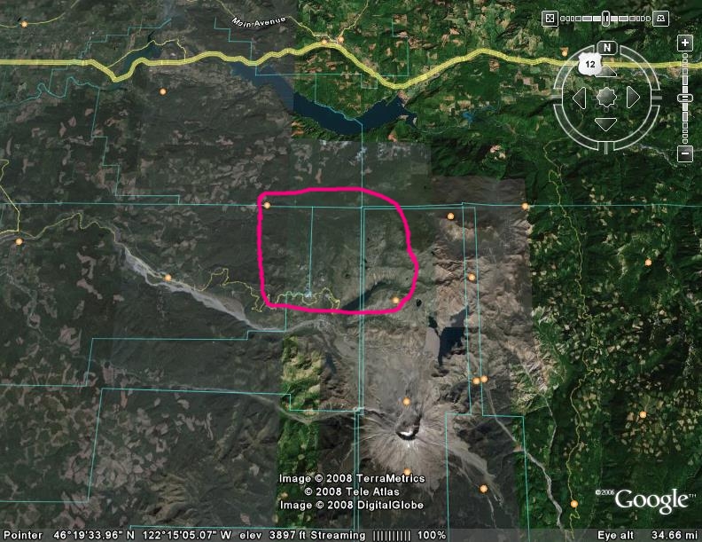
It's in the circled area. I'm pretty sure anyway.  Like I said, I was pretty sleepy... Like I said, I was pretty sleepy...
 |
| |
Snowkite.jpg |
|
|
|
chanson

Since 31 Jan 2006
1874 Posts
WISCONSIN
Chimey
|
| Fri Apr 11, 08 3:14 pm |
|
|
Wow Mike...
That would be sweet!!
nice find... 
|
|
|
Spike

Since 13 May 2007
1414 Posts
Alameda
Spelling Expert
|
| Fri Apr 11, 08 4:54 pm |
|
|
| could it have been a river/stream? looks like there are a few that look big enough to be mistaken for roads on google maps
|
|
|
Nak
Since 19 May 2005
4335 Posts
Camas
Site Lackey
CGKA Member
|
| Fri Apr 11, 08 5:36 pm |
|
|
No, it's not a river... LOL I have enough experience as a USAF pilot to tell the difference, really. 
Main features: The road approaches from the west, winding up to the area. The road either ends, or the plowing ends, at the area. The area is several miles across, comprised of gently rolling hills with minimal vegetation/obstructions. The area is the high terrain in the immediate vicinity, with terrain dropping in elevation outside the target area. I'm guessing the elevation to be 3500 to 4500 feet, based on snow cover and comparing it to ST Helen's. There is some possible vegetation in the immediate vicinity of the road, possibly requiring hiking in approximately 100 meters to access open terrain. Unfortunately, this vegetation would possibly render the area difficult/impossible to identify from the road.
|
|
|
trailboss

Since 08 Aug 2006
96 Posts
HR
|
| Fri Apr 11, 08 6:45 pm |
|
|
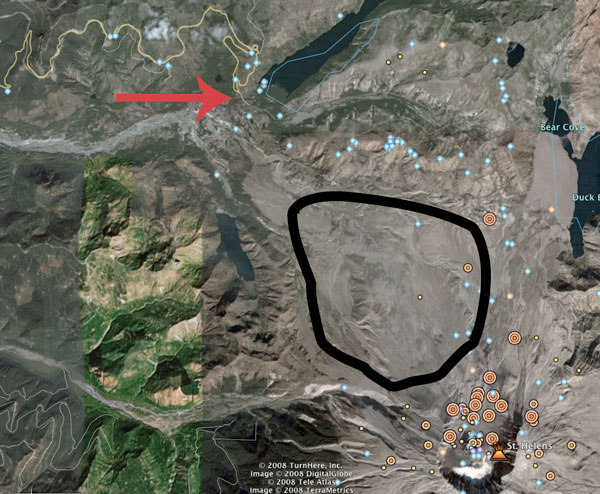
I flew that route a few days ago, and I think the spot is actually quite a haul and a pretty good elevation gain from the road. If it's the same spot in this picture circled in Black. I was checking that out as well and dreaming of the snow kite possibilities.
 |
| |
sthelens.jpg |
_________________
__________________________________________ |
|
|
Kraemer
Since 24 Apr 2006
1736 Posts
Sky Pilot
Unicorn Captain
|
|
|
Mark
Since 20 Jun 2005
3679 Posts
I need my fix because I'm a
Naishaholic
|
| Fri Apr 11, 08 8:01 pm |
|
|
I believe the area in black is "off limits" and a nature study area. 
_________________
Cleverly disguised as an adult...
www.naishkites.com |
|
|
Nak
Since 19 May 2005
4335 Posts
Camas
Site Lackey
CGKA Member
|
| Fri Apr 11, 08 8:12 pm |
|
|
Hey Trailboss! Thanks for the help, but that's not the spot. (It would be nice to get in there though!) If you fly that again, keep an eye out for a spot with road access. There's something there waiting... If not the spot I saw, i think there's enough terrain that there's a spot that you can't see from the road. If we don't find it this year, I'm going to check out in a bug-smasher and find that spot next winter. 
|
|
|
registered

Since 12 Jul 2005
1319 Posts
tsunami
Sandbagger
|
| Sat Apr 12, 08 8:22 am |
|
|
flying over southern oregon always brought my attention to spots I could never locate either..
the spots are out there it just takes some dedicated souls to find it and figure it out.
|
|
|
boredbrain
Since 16 Feb 2006
352 Posts
Hood River
Obsessed
|
| Sat Apr 12, 08 5:50 pm Is this it? |
|
|
In my search for a second sled I have been asking about spots.
Looks like the research spot on the North side, Pumice Plain.
Got second sled, was still lots snow at Lone Butte last weekend.
Any one up for late seasons Helen
|
|
|
|