|
previous topic :: next topic |
| Author |
Message |
stringy

Since 23 Jun 2006
1731 Posts
vancouver
XTreme Poster
|
 Sat Apr 15, 17 7:01 am sandbar april 14 Sat Apr 15, 17 7:01 am sandbar april 14 |
 |
|
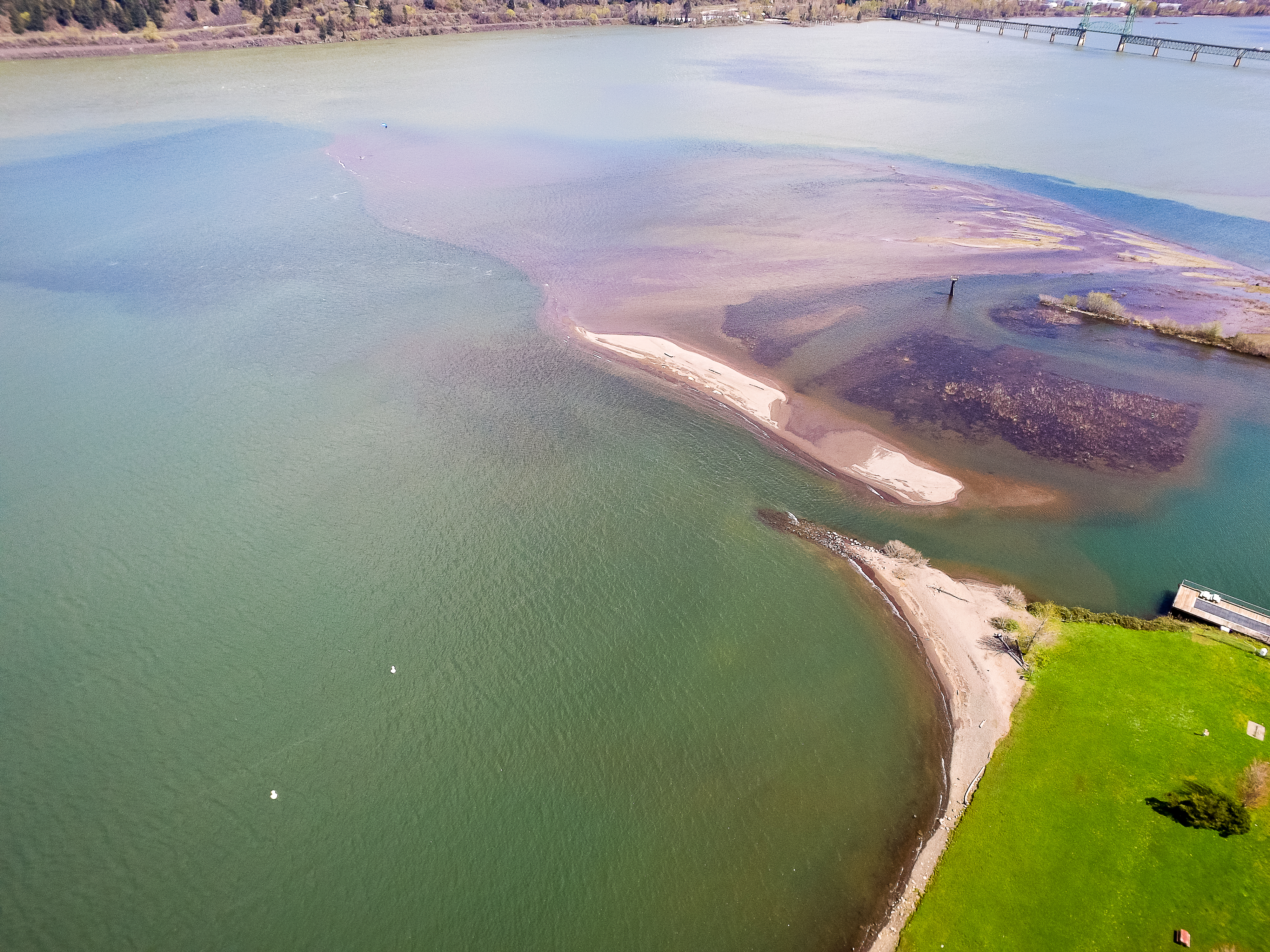
here's a shot of what the sandbar looks like as of yesterday at current water levels.

_________________
www.jimstringfellow.com |
|
|
D-Krep It Kiter

Since 18 Jul 2011
417 Posts
Obsessed
|
 Sat Apr 15, 17 6:09 pm Sat Apr 15, 17 6:09 pm |
 |
|
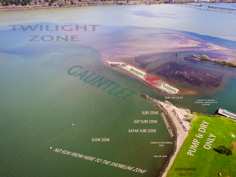
Plenty of room for everyone!
 |
| |
Event Site Usage_1.png |
|
|
|
wannabekiter
Since 14 May 2015
269 Posts
Hood river
Obsessed
|
 Sat Apr 15, 17 6:21 pm Event site Sat Apr 15, 17 6:21 pm Event site |
 |
|
Awesome map and zone info.. But you forgot the dog shit area. That's in the pump and dry zone if I remember correctly. 
|
|
|
wylieflyote

Since 30 Jun 2006
1647 Posts
Puget Sound & Wa. Coast
XTreme Poster
|
 Sun Apr 16, 17 4:10 am Sun Apr 16, 17 4:10 am |
 |
|

_________________
CGKA Member
-------
Kip Wylie |
|
|
Kmun
Since 05 Jul 2009
256 Posts
Obsessed
|
 Sun Apr 16, 17 12:43 pm Sandbar Destruction Via Sandbar "Clean-up" Sun Apr 16, 17 12:43 pm Sandbar Destruction Via Sandbar "Clean-up" |
 |
|
Attention: Sandbar Clean-up Crew!
These photos should confirm and guide thoughtful placement of wood debris.
Notice the erosion channel at the north edge of Marine Park now cutting a short-cut path (east to west) through the boat basin. This will soon change our seasonal DRY sand peninsula into a year-around island. All foot access to the "dry island" will soon be impassible and too deep to ford across.
Stop the delta cut:
Let’s get it right people. Spring floods deliver gifts of wood. This debris can be move into the eastern edge of this new west bound arroyo. This wood substrate will soon be anchored by rocks and sand halting the evolution of the new short cut delta channel. Do NOT BURN these high value gifts from the river! Large logs and even bundles of branches can pulled to place of greatest utility. functional position.
Honor the origins:
Born in from Glacial burst on November 7, 2006 this onetime thirty-five-acre "public park" is once in a lifetime gift. It has been receding from birth. Besides erosion from the Hood River to the east and the Colombia on the north this new southern delta channel will eat its way across your playground from south to north. Make no mistake, this sand bar is receding. Erosion now from three sides, will be catastrophic.
Secondary benefits:
Stopping the Hood River from cutting the new delta channel/short cut will send coherent river power and volume directly to the northern end of the sandbar. The confluence dynamic with the Columbia will keep the shipping channel deep while enhancing the eddy around the northwest point. This is an improved condition will create more sand deposition onto the northwest aspect of the point. Viola! Constructive deposition (sandbar building) instead of erosion!
Stand up and be counted:
Speak now or forever use a dang boat to get out onto the sandbar. The spring sandbar clean-up is a voluntary effort. Community guidance has value. All users of the sandbar can voice support or constructive thoughts by posting here & now.
Last edited by Kmun on Mon Apr 17, 17 10:56 am; edited 2 times in total |
|
|
ldhr
Since 21 Jul 2009
1487 Posts
Hood River
XTreme Poster
|
 Sun Apr 16, 17 2:42 pm Sun Apr 16, 17 2:42 pm |
 |
|
Kmun - have you participated in the cleanup the past few years?
We've been burying the larger logs as you suggested.
The smaller stuff needs to be removed to prevent line tangles and launch hazards.... but the big logs should be buried and left in place as anchors.
Last edited by ldhr on Mon Apr 17, 17 10:20 am; edited 1 time in total |
|
|
Pepi

Since 16 Jun 2006
1831 Posts
Pure Stoke Sports
Shop Owner
CGKA Member
|
 Mon Apr 17, 17 8:02 am Mon Apr 17, 17 8:02 am |
 |
|
Side note of information on northend tip of sandbar, it is extending out further and is shallower than you might think.
Reports from sailors and fishermen is that the sandbar depth just inside of the red buoy is around 7-9ft deep right now (at super highwater level). Not sure how this will play out as the spring water levels bounce up and down, but will be interesting.
Mostly take note of this if you are a boat owner and tend to cut inside of the buoy when returning back to the marina.
As always, Mother Nature Rules All, and she can change the rules anytime she pleases.
_________________
Pure Stoke Sports
Hood River, OR
http://www.facebook.com/pages/Hood-River-OR/2nd-Wind-Sports/35891485558?ref=mf
www.Purestokesports.com |
|
|
Kmun
Since 05 Jul 2009
256 Posts
Obsessed
|
 Mon Apr 17, 17 3:19 pm Mon Apr 17, 17 3:19 pm |
 |
|
| ldhr wrote: | | Kmun - have you participated in the cleanup the past few years? |
Participation?
Over the years I attended at the first heavy equipment, diesel-fueled bonfire fest and one other cleanup. By the day of those events it is much too late to effect the mayhem with onsite reasoning. The atmosphere is rightly one of gettin' er done! And yes, under early spring twilight there may have been a shadowy figure out there with a grain scoop, sinking logs deep into the sand. It's sort of like gardening and beats going to the gym!
Leveraging thought before action:
A greater contribution may be an annual preemptive warning to what is now coming to pass. I am happy to hear that burying logs (as substrate) is now employed.
MOST URGENT:
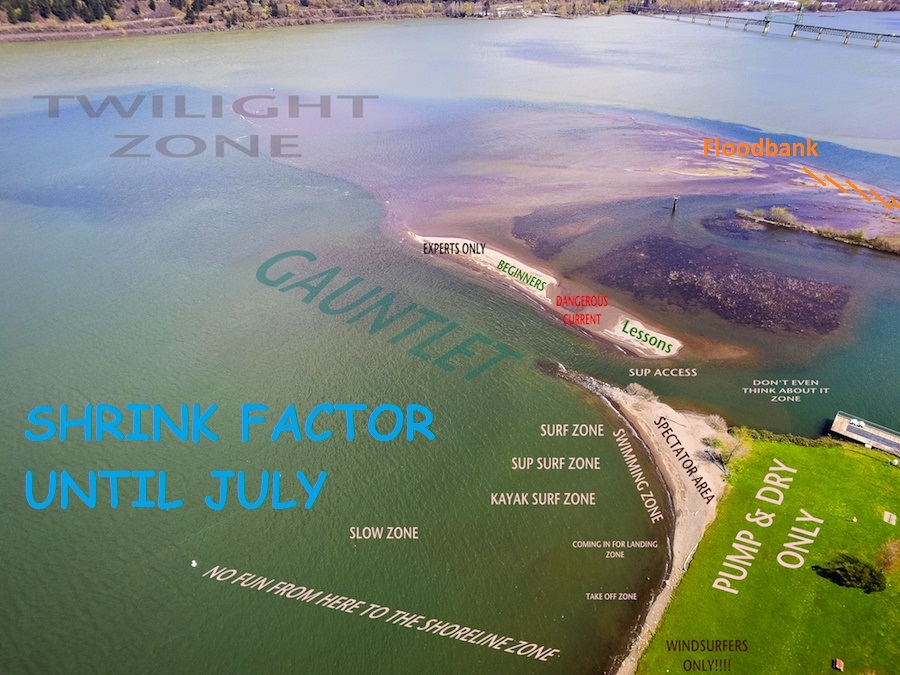
It is wise (unless otherwise) to address this evolving delta-channel making its’ path through the boat basin. Ignore this and we can expect to see disappointing changes between the Event Site point and Sandbar island.
The crossing ford on the map labeled "Sup Access" will change to...
1. increasing current
2. a wider channel
3. a greater depth.
It will become a “swim only” crossing & not kid safe.
Study the image below of a proposed drift wood deposition zone/flood-bank. Orange slashes indicate proper log orientation angles overlaped for water deflection with most efficient order to skid and set of logs (south to north).
I would be happy to meet (ASAP) to plan & flag off the zones in which to drag and deposit logs. (send PM/private message).
 |
| |
Sandbar Floodbank 10.jpg |
Last edited by Kmun on Mon Apr 17, 17 9:20 pm; edited 2 times in total |
|
|
hilton
Since 15 Aug 2008
798 Posts
Opinionated
|
 Mon Apr 17, 17 6:12 pm Mon Apr 17, 17 6:12 pm |
 |
|
I was checking out the sandbar the other day on my SUP.
As noted, the channel between the Event Site and the Sandbar (SUP Access) is very deep (approx. 5 feet) so currently not easy to access the island on foot.
But the area of the Twilight Zone where you can see the kiter in the original pic is still very shallow (12"-18" deep) well out towards the middle of the river.
It's also worth noting a vey steep drop off on the west edge of the sandbar where the depth transitions quickly from 12" to 5'+
|
|
|
97031

Since 22 May 2008
145 Posts
Hood River
Stoked
CGKA Member
|
 Wed Apr 19, 17 2:36 pm Wed Apr 19, 17 2:36 pm |
 |
|
I've organized the sandbar cleanup for about the last five years as part of the CGKA, which I've been a board member for about ten years. Without getting into the weeds of of Kmun's comments and suggestions, here's my feedback:
1. We only have permission to do limited removal of immediate hazards on the sandbar. We work with the port to gain approval and vehicular access for our work party, but do not have the ability to do any "shaping" projects. This would require Fish&Wildlife, Army Corps, Department of State Lands, etc. permitting that we don't have the resources to pursue. There is so much red tape involved with any kind of work near the water that we're fortunate to be able to do what we've been doing.
2. In terms of liability, it would be an unreasonable risk to intentionally deposit anything anywhere near where people are recreating that is not completely buried. Our goal is simple- remove as many hazards as possible in the short amount of time we have, with the limited amount of volunteers we have.
3. The sandbar is not shrinking. It is evolving and shifting every year, but it is not simply getting washed away. To be accurate, we are talking about two sandbars- one west of the Hood River and one to the east. They were there before the river was dammed, the Bonneville pool covered them for several decades and now they are back above water. They will grow and spread and morph as more and more material from our shrinking glaciers gets washed down our rivers, but they most definitely are not headed out to the Pacific Ocean. Who wants to take bets on how long it takes before windsurfers can't use the Event Site because it's too shallow all the way across? The problem from here forward isn't going to be "how do we save our sandbar. It's going to be "how do we keep the shipping channel navigable for barges."
4. The channel between the Event Site and the sandbar isn't getting bigger or deeper, it has filled in year after year. It will never fully connect due to water flowing out during some months, when the Hood River is high enough to leech through the rock jetty heading out to the spit, or when the Columbia rises and water flows back into the boat basin. If you've kited here long enough you'll remember a swim out to the sandbar and back with your gear was just par for the course, even in the middle of summer when water levels were lower.
4. If you're worried about the Hood River carving the sandbar away, go out to the eastern edge and try to dig a hole.
|
|
|
tkaraszewski

Since 21 Oct 2016
41 Posts
Hood River
|
 Wed Apr 19, 17 4:16 pm Wed Apr 19, 17 4:16 pm |
 |
|
| How/when can we volunteer to help with this year's cleanup?
|
|
|
|


